
The flood warning for the Bow River in the Bow Valley here issued by Alberta Environment early Monday (June 13) due to significantly rising water levels has been downgraded to a flood watch due to lower than forecast rainfall for the region.
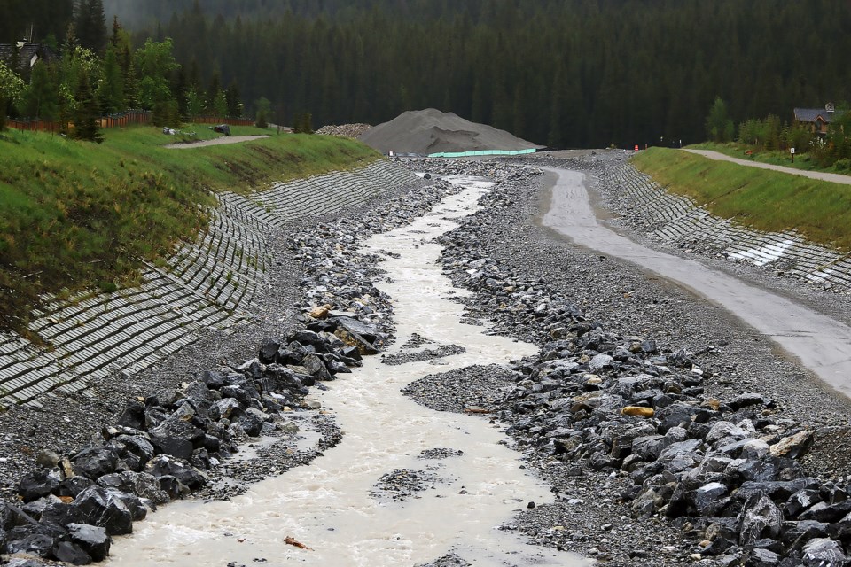
Town of Canmore officials say Cougar Creek is currently flowing to Elk Run Boulevard. Canmore suffered catastrophic flood damage in the 2013 floods, including destruction of homes along Cougar Creek when it burst its bank.
"It is anticipated that the existing flood mitigation work on Cougar Creek will maintain the flow in the channel," said Adam Robertson, a spokesperson for the Town of Canmore.
"The Bow River is rising, however current modelling is showing the peak to be lower than previously expected. Current modelling shows the flow should remain in the protected channel."
The communities were put on flood warning on Monday (June 13), with Alberta River Forecast services indicating the next 12 to 14 hours will be critical.
Silvio Adamo, Banff’s fire chief and director of protective services, said the municipality was notified by Alberta flood monitoring agencies at about 2 p.m. on Sunday that modelling was showing that Banff could see “significant and rapid” rises in river levels and flow rates.
“The numbers that they were using at that time exceeded the levels that we had experienced historically, including 2013, so obviously we took that very seriously,” said Adamo.
“It’s been a busy 24 hours…we’re getting information live here, moment-by-moment.”
Both the municipalities of Banff and Canmore have activated their emergency coordination centres.
An incident command post was set up at the Banff fire department. Canmore's incident command trailer was set up at the Cougar Creek parking lot for monitoring purposes.
Adamo said crews, primarily from the fire department, worked from late Sunday afternoon to about 11 p.m. to start setting up Tiger dams – a series of water-filled tubes that create a flood barrier – near Birch Avenue properties on the south side of the Bow River.
He said all 130 units in the Birch Avenue housing development were alerted.
“We’ve been working with the management team in the Rocky Mountain Co-Op,” he said.
“They have been outstanding and since 2013 have made a number of improvements and stayed on top of their mitigation efforts within their building.”
In Canmore, Robertson said there are three areas being monitored, including groundwater levels, steep creeks and the Bow River.
He said the emergency coordination centre has been activated to prepare for all scenarios, cameras have been set up to monitor key areas along the Bow River and steep creeks and sandbags are being prepared for flood mitigation.
Roberston said sandbags are available for residents while supplies last, and can be picked up at the Public Works building parking lot, located at 100 Glacier Drive.
“Residents with basements and crawl spaces should consider raising items,” he said in an email.
The groundwater levels are currently high and it is anticipated that they will likely start creating issues in low lying areas.
Robertson said Canmore is expecting significant flow on steep creeks.
“It is anticipated that the existing flood mitigation work on Cougar Creek will maintain the flow in the channel,” he said. “We will continue monitoring all steep creeks during this event.”
It is expected the Bow River will continue rising, with current modelling showing the flow will remain in the protected channel.
“We are in communication with the Alberta River forecast centre for regular updates,” he said.
“We will continue to monitor the flows, and respond as necessary.”
James Eastham, a Parks Canada spokesperson for Lake Louise, Yoho and Kootenay, said Parks Canada is actively monitoring water levels on the Bow and Pipestone rivers in Banff National Park, as well as waterways in Yoho and Kootenay national parks.
“Parks Canada staff are monitoring trails, campgrounds and other facilities and will implement closures as needed,” he said.
“We are also working with stakeholders who may be directly impacted by high water levels to advise them of what precautionary measures they can take,” he added.
“At this time, severe flooding is not expected. However, in the event conditions change, Parks Canada has an incident command team that would take over to manage the response as needed.”
Traditionally, Banff sees the Bow River reach its seasonal high mark around the third week of June.
There are many factors related to this including snowpack, temperature at higher elevations and precipitation.
Since the 2013 floods, Banff’s flood team has enhanced its flood mitigation strategies and tactics with the help of provincial grants to secure flood mitigating equipment.
The Town has approximately one kilometre of Tiger dam flood barriers to deploy, pumping equipment, and a sand bag-making device that attaches to a skid steer that can produce thousands of sandbags in very short order.
Within Banff’s flood plan, the Town of Banff has established trigger points based on river flow to deploy certain tactics, including closing trails from the canoe docks to the gazebo at Central Park and Birch Avenue to the YWCA at river flows of 230 cubic metres per second; and closing lower the Bow Falls viewing platform at 300 cubic metres per second
“Banff’s flood team will continue to monitor river levels and information received by Alberta River Forecasters and take appropriate actions when needed,” said Adamo.
Adamo said considerable work was done to date on deploying the dams.
“We have probably another 12 or 14 hours of time to have the Tiger dam completed, deployed and filled and protecting the Birch Avenue housing,” he said.
The Town's emergency personnel have halted deployment of temporary dams around the lowest elevation in Banff at Birch Avenue and the Recreation Grounds.
Adamo said the Town will continue to monitor the river levels and flow rates.
“We will continue to look to either make those decisions live hour-by-hour here as we get updated information from forecasters," he said. "It is very dynamic and fluid right now so we’re doing the best we can to interpret information.”
By mid-afternoon Monday, Banff’s river height was at 2.86 metres and was flowing at approximately 154 cubic metres per second.
As a reference point, the peak of the 2013 floods saw the Bow River in Banff reach approximately 440 m3/s.
“Obviously, we would typically not even have hit where we are issuing warnings, but because of the advanced warning from Alberta Forecasters we’re erring on the side of caution,” said Adamo.
“If their predictions come true, we will reach all of those benchmarks, and surpass them.”
Since the catastrophic 2013 floods, Adamo said the Town of Banff has done a lot of mitigation work to be better prepared for floods, such as backup generators for lift stations and water wells.
“We’ve made changes to sanitary lift stations and upgraded groundwater issues in the Elkwoods area,” he said.
“We now have the Muskrat pedestrian bridge in place that allows for additional resources and access across the bridge should we need that.”
Outside of the Banff community, Canadian Pacific Railway has added culverts upstream of the transfer station and Parks Canada has rebuilt and fortified the Carrot Creek bridge on the Trans-Canada Highway
“It’s worth noting the Minnewanka dam has a very low level and so there’s significant capacity to retain water there from that area of runoff where we also had significant issues in 2013,” said Adamo.
Banff Mayor Corrie DiManno thanked Chief Adamo and the fire department and emergency coordination centre team.
“We’re no strangers to information coming quickly and having to mobilize quickly… we are a well-oiled machine now, and it is such a comfort that we are ready to respond,” she said.
“I want to really express gratitude for all the work you’re doing to be proactive and prepared, and not just the last 24 hours, but since the lessons we learned in 2013.”
At Stoney Nakoda, Nakoda Emergency Management is monitoring the rainfall and flood situation closely. Nakoda Fire and Nakoda Protection will be working alongside Cochrane Search and Rescue for the foreseeable future as this situation develops.


