
BOW VALLEY – The Bow Valley communities of Banff, Canmore, Exshaw and Lac des Arcs remain on flood watch as communities prepare for possible flooding.
The Municipal District of Bighorn has declared a state of local emergency for the hamlet of Lac Des Arcs due to flooding concerns.
“At this time there is no imminent threat to any private dwellings,” according to notice from the MD. “The MD of Bighorn is taking this step to address erosion concerns on Heart Creek which may require the utilization of heavy equipment.”
Town of Canmore officials say the emergency coordination centre has not recommended a state of local emergency at this time based on the current situation.
“If conditions change, we are prepared to declare a state of local emergency,” said Adam Robertson, a spokesperson for the Town of Canmore.
A flood watch means that stream levels are rising and will approach or may exceed river banks, whereas a flood warning means that rising river levels will result in flooding of areas adjacent to the streams affected. The Bow River from Banff to Exshaw was downgraded from flood warning to flood watch late Monday afternoon.
The region saw steady rainfall overnight Monday, with moderate to heavy rain expected to continue throughout Tuesday before tapering off Tuesday night and into Wednesday.
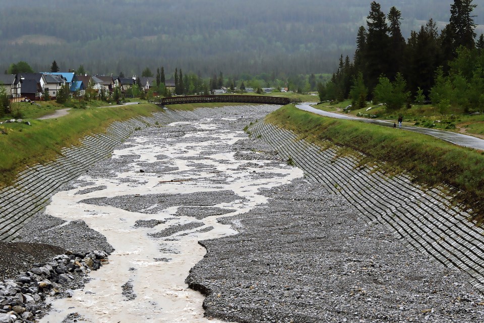
The Bow River through Banff is running at about 154 cubic metres per second, which compares to more than 400 cubic metres per second during the height of the catastrophic 2013 floods.
John Pomeroy, a Canmore-based University of Saskatchewan hydrologist and Canada Research Chair in water resources and climate change, isn’t overly worried for the Bow Valley at this time.
“We need to be extremely wary, this is an extreme event, and we’ve had a combination of a very heavy precipitation system with high mountain snowpack,” he said.
“But it so far doesn’t look like this is going to be an event that causes widespread damage.”
Pomeroy said one of the key differences between the current situation and the 2013 floods is the level of precipitation.
“We have more snow in the mountains now than we did in 2013, but the amount of rain is simply not the same,” he said.
“We had 250 millimetres of relatively warm rainfall right up on the mountain tops occurring around Canmore and in the Kananaskis area in 2013, and 350 mm down in south Kananaskis,” he added.
“So far, 135 mm has been measured – that’s the maximum – and a lot of the numbers are closer to 60 to 90 mm, depending where you are, and it’s quite a bit lower in Banff.”
On top of that, there is also a cooler weather system this time around, meaning snow is falling at higher elevations instead of rain.
“That’s been good for us. It’s falling almost completely as snow at higher elevations so that’s building up that snowpack. It’s wet snow so it will melt over the next few days so it’s not going to melt really quickly,” he said.
“Snow can only melt at about 40 to 50 mm per day, but rain can fall at hundreds of millimetres per day, and so that’s where rainfall gets us into trouble, whereas snowmelt, just because of the physics, can really never exceed 50 mm per day.”
A shift to warmer temperatures at higher elevations could alter the situation, though.
However, Pomeroy said by the time temperatures reach an expected 10 to 15 degrees Celsius at higher elevations on Wednesday, much of the rain is expected to subside.
“A lot of the precipitation will be finished by then, so I think it’s not going to warm up until the storm is over,” he said.
“Then we will see the snow melt over a week or so, keeping stream levels high but not dangerously high.”
As for Cougar Creek in Canmore, which burst its banks in 2013 and destroyed several homes, the rainfall is nowhere as much.
Pomeroy said there is now a weather station up Cougar Creek, which wasn’t there in 2013.
“It’s had 80 mm of precipitation in the last two days, which is quite a lot, but it’s not the 250 mm that it had in 2013,” he said.
Pomeroy said he has more concerns for communities like High River, Okotoks and Black Diamond because of conditions in Kananaskis Country.
He said there has been more than 130 mm's of rain in the Sibbald area and some rivers have jumped up seven-fold from Monday to Tuesday morning – and there’s lots of fresh snowfall up high.
He said a snow model has predicted about half a metre depth of fresh snowfall in the Kananaskis front range, with some expected avalanches.
“The Elbow River also looks like it’s getting a lot of precipitation… it might be quite flashy,” he said.
The Town of Canmore’s emergency coordination centre continues operating around the clock to keep close tabs on all steep creeks and the Bow River, while the incident command trailer remains at the Cougar Creek parking lot for monitoring purposes.
The municipality has set up cameras to monitor key areas along the Bow River and steep creeks and has prepared sandbags for flood protection ready for deployment in key areas if needed.
Sandbags are available for residents while supplies last, and can be picked up at the Public Works building parking lot at 100 Glacier Dr.
Robertson said the Bow River and steep creeks all continue to run in their channels.
“Water levels in steep creeks and the Bow River are expected to rise throughout the day, however, we do not expect any of them to create major issues,” he said.
Robertson said Cougar Creek is currently flowing to the Trans-Canada Highway.
“It is anticipated that the existing flood mitigation work on Cougar Creek will maintain the flow in the channel,” he said.
Robertson said the Bow River is rising, however current modelling shows the peak to be lower than previously expected.
“Current modelling shows the flow is expected to remain in the protected channel,” he said.
Robertson said groundwater levels remain high so residents can expect to see water ponding in low-lying areas. He said nuisance flooding in ditches adjacent to Stoneworks Creek and possibly on select trails along the Bow River are expected.
“Exercise caution and vigilance as forecasts and river conditions will continue to change quickly. Stay away from creek and riverbanks when flows are high,” said Robertson.
Pomeroy had high praise for the Town of Canmore and other agencies in handling this week’s developing flood risk situation.
“I think the preparedness of the Town has been exemplary … to see the Town engineering employees out looking at everything and the emergency services being prepared beforehand is just wonderful to see,” he said.
“The province has also been right on top of this one as it came through with their forecasting and information, and then also so far Environment Canada weather models have been fairly accurate as to what would happen … that’s a big improvement from 10 years ago.”
Pomeroy said there are more weather stations at higher elevations, more stream flow gauges and better models to help communities be more aware and better prepared.
“Kudos to all these groups for taking seriously what’s happened, which is what you’d expect after what we went through,” he said.
“I think 2013 was a good learning experience, apart from being a horrible disaster, it’s great to see governments learn from that and operate in such a safe way.”
For Canmore residents to stay up to date, visit canmore.ca/emergency.


