
CANMORE – A long awaited debris retention structure designed to protect the neighbourhood of Cougar Creek from catastrophic steep creek flooding could face further delays.
During an update to council, administration revealed the $48 million structure, which was approved by the Natural Resource Conservation Board (NRCB) in November, had major changes to elements of its design from the original plan because the project exceeded the budget.
As a result, the NRCB will either need to amend its decision or issue an addendum, however it’s not clear how long that could take. The Environmental Impact Assessment (EIA) that was also approved by Alberta Environment and Parks in March 2018 may also need to be reviewed.
Felix Camire, the project manager, told council the new plan is expected to be significantly cheaper to build and could reduce construction time by six to 12 months, making up for any lost time caused by the approval process.
“What we’re counting on is the potential increase in timing for approvals would be compensated by the decreased construction duration, so hopefully we’re not affecting the overall completion of the project,” said Camire, acknowledging they are not sure how long the approval process could take.
Previously it took the NRCB nine months to approve the original design, however this time around he said the project team is hopeful the NRCB will approve the new design in a quicker fashion because the new design retains the same risk reduction to residents and infrastructure downstream, does not change the structure location and it is designed to the same standards as the previous plan.
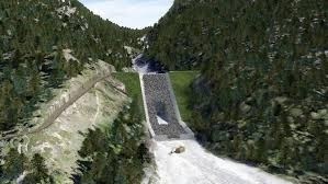
According to Camire, one of the biggest benefits with the new design is truck traffic from construction is expected to be reduced by about 80 per cent because a lot of the material for the dam will be taken from a new spillway that will be blasted through the side of the mountain.
“It reduces the complexity of the structure massively,” said Camire, referring to the rock cut spillway.
“The concept right now is to look at something like one, or maximum two blasts a week, that would be scheduled.”
He told council the new design will require more blasting to build the rock cut spillway, which will be 20 metres at its deepest point.
According to Camire, the new plan will also have a smaller impact on the wildlife corridor because more of the access road will built within the footprint of the structure itself, however there will be changes to habitat availability, connectivity and mortality risk because some animals could become trapped in the spillway.
To mitigate some of the environmental concerns, he said the project team has looked at adding wildlife ramps along the side of the spillway and the reduction in truck traffic will offset the increased disturbance from blasting.
There has also been discussion about installing signs in the area that would prohibit people from accessing the structure including the possibility of fines.
According to Camire, Canadian Hydrotech Corporation completed the original design, however in August Canadian Projects Limited (CPL) updated the cost estimates for the project and determined it would likely cost more than expected.
As a result, a review of the original design was undertaken to try to find ways to cut costs, however even after finding several million dollars in savings the design still exceeded the budget.
“In November 2018, we got the finalized version of the cost estimates that basically showed that the project would most likely be about 10 per cent over budget if we just kept going with what we had proposed,” said Camire.
As a result, CPL recommended the Town consider replacing the concrete spillway located on the downstream side of the structure with a rock cut spillway cut into the side of Grotto Mountain.
Camire said the rock blasted and excavation from the spillway will be used as fill for the structure.
With the spillway located adjacent to the structure, he said the access road will be located on the structure itself, which will decrease costs and eliminates the need to build the majority of the road within the wildlife corridor.
According to Camire, the new design was reviewed in depth against the original findings of the EIA and the Town’s consultant concluded that the original findings remain valid.
“The revised design doesn’t change the findings of the original assessment,” said Camire.
That being said, the new design will have a different visual impact and minor mitigation will be required to account for the larger project footprint (0.5 hectares) and the revised spillway location.
Camire said the new design still meets the safety standards set out by the Canadian Dam Association and Alberta’s Dam and Canal Safety Guidelines.
AEP Dam Safety and a third party reviewed the new design in December and found the new design was “attractive” from a technical perspective, particularly the rock cut spillway because it is a low-maintenance solution.
Based on the evaluation of new design Camire said the project team adopted the majority of the recommendations and in early January the project team provided an update to Alberta Parks, AEP and the NRCB. A project update will also be submitted to Treaty 7 First Nations in the coming weeks.
Before construction can begin, the project will also need regulatory approval under the province’s Water Act and a land disposition agreement must be in place with AEP.


