
CANMORE – Researchers from the University of Saskatchewan have developed a model to predict snowpack levels in the Rocky Mountains that will provide a better understanding of the effects of climate change and annual spring runoff levels.
The university's Global Water Futures program is headquartered in Canmore – in the headwaters of the mountains – with the research and results from the modelling being published in February in the journal The Crysophere. The model provides a high degree of accuracy for water management and flood forecasting, according to its authors.
"The objective of the present study is to develop and evaluate a novel strategy for multi-scale modelling of mountain snowpack over large regions and for entire snow seasons," stated the research article "Multi-scale snowdrift permitting modelling of mountain snowpack."
Traditional methods to measure snowpack and snow density are labour intensive and require teams to travel into the backcountry to take measurements. The new modelling has proven to be highly accurate at predicting these levels, which helps those who rely on this information for planning purposes.
John Pomeroy, Canada Research Chair in Water Resources and Climate Change, said the model is significant because it provides a detailed daily picture of the snowpack in the mountains, with a high degree of accuracy.
"The reason we want to know the snowpack in the mountains are many," Pomeroy said. "The model can go to a resolution of 50 metres, which is down to the ski slope scale and it can tell us a lot about ski conditions and backcountry travel conditions, and even conditions for municipalities in relation to snow clearing and snow removal."
Other reasons include understanding how snowpack levels affect the ecosystems in the mountains, as well as how it's directly tied to drinking water systems for millions of Canadians.
The snow that falls each winter in the Canadian Rockies, on the eastern side of the Continental Divide, accounts for 60 per cent of the water flows in the South Saskatchewan River, which the Bow River flows into. It provides drinking water for residents of Alberta and Saskatchewan, as well as flows to support agriculture and other industries.
The new modelling will help predict the development of the mountain snowpack, Pomeroy said, and allow better management of those resources.
The Canadian Hydrological Model (CHM) is run on super-computers that use detailed data on snow distribution by wind and avalanches, shading by mountains, wind flow over ridges and below treeline, as well as weather forecasts, to estimate snow levels with a high level of detail.
A 1,000-square-kilometre area of the Kananaskis Valley was modelled and the results were a close match with the snow depth data collected by scientists from the University of British Columbia using LiDAR (light detection and ranging) laser measurements taken from the air. High-resolution snow cover data from satellites and analyzed by a lab at the University of Toulouse in France confirmed the model was successful.
A website that demonstrates the modelling for the Bow Valley was created, called Snowcast. It generates almost real-time estimates for the region, from Field, B.C. to just west of Calgary.
Vincent Vionnet was lead author on the study, while post-doctoral fellow Chris Marsh with the University of Saskatchewan developed the CHM with the Global Institute for Water Security and the department of geography and planning.
Marsh said the model's success is exciting because there is potential to expand it and look at larger geographic regions, such as the North American Cordillera.
“Very large spatial extents are now solvable with a model like this,” Marsh said in a press release. “It’s really important for being able to provide estimates for the amount of end-of-winter snow cover in difficult to access mountain areas. Simulations provide a missing piece of the puzzle for helping quantify the amount of water in mountain snow cover.”
Pomeroy noted the global applications of the model are already generating interest, which will support better water management around the world, especially with extreme events, like droughts and floods. He added the model is open access, meaning it is publicly available for use.
"At global water futures, we are a taxpayer funded research network, we cannot ethically sell this stuff, we have to make it available to the public," he said.
Vionnet spent two years working with Global Water Futures on the project, contributing the design for validating it and a strategy for the difficult task of accounting for mountain wind behaviour. He is now a research scientist for Environment and Climate Change Canada, which will benefit from the CHM as an open access tool to improve forecasts in mountain regions.
The reason why modelling the effects of wind was so important, said Pomeroy, is it redistributes snow in different ways, depending on the location. Where the snow is located is also a factor, above or below treeline, and the wind dynamics in mountain landscapes can include accelerating up slope and decelerating downslope – all of which has to be incorporated into this model for it to work.
Pomeroy said the 2013 flood that affected Canmore and Calgary was one of the motivations for developing the model. The CHM would provide an earlier warning for the conditions that led to the mountain creek debris floods and overland flooding that occurred.
"The mountain snowpack in late June that year was higher than one would expect and its levels were not well understood, and not well predicted by any model at the time," he said.
At the beginning of February, a flash flood in the Himalayan state of Uttarakhand in India killed at least 30 people and destroyed two hydroelectric power stations.
Speculation around the cause of the flood included the possibility of a glacial lake outburst flood or a landslide, resulting in the torrent washing down valley, destroying infrastructure and killing people caught in its wake. There was speculation around the role that climate change played in the event.
Pomeroy said climate change is resulting in the loss of permafrost, which holds sediments in place, and provides more material for a debris flood or torrent to occur. He said there is evidence part of a glacier did break off prior to the flooding and may also have tied into a landslide.
It sparked questions in the Bow Valley about the potential for a glacial lake outbreak flood to happen here, but Pomeroy said such events in the Rockies are not a concern. But when it comes to a debris landslide, or icefall from a glacier, that can happen in this region.
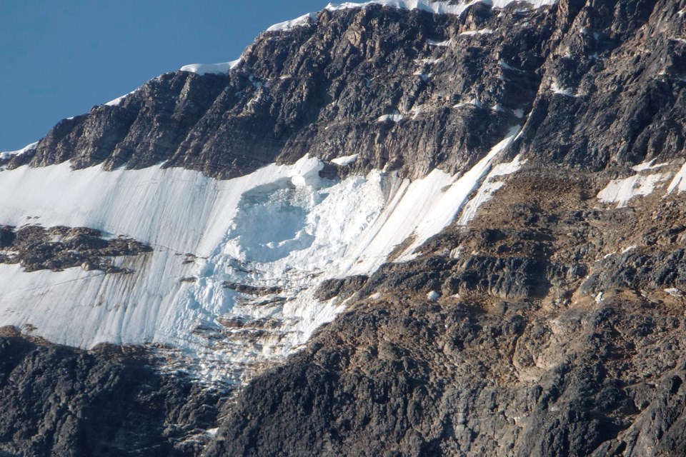
There was such an event in August 2012 at Mount Edith Cavell. A large piece of the Ghost Glacier fell off at night into the nearby Cavell Pond, resulting in waves that destroyed the nearby parking lot and road.
"If that happened during the day, with people there, we would still be talking about it," Pomeroy said.
While glacial lake outburst floods don't present a significant risk to the Bow Valley, he said the loss of glaciers and permafrost in the region can leave behind boulders and sediment that would be easily moved by extreme water events.
"That is what we have to focus on here in the Rockies," Pomeroy said. "We are losing our glaciers, no doubt about it, and the question is – what is left afterwards?"
It ties into climate change as glaciers melt faster, the permafrost melts, more extreme rain events occur and ocean levels rise. Pomeroy said all these systems are interconnected.
"It gets really complex and it is hard to say 'if this happens, what happens next?' " he said. "We have models where we develop that and can predict some of it, but there is a lot of uncertainty."
It is just one of the hazards faced in the mountain landscape, along with flooding. Pomeroy completed another new study focused on the Bow Valley he presented to officials at the City of Calgary and province of Alberta.
The study looked at the 2013 flood and what it would look like if it happened at the end of the century. The results found by that time, the snowpack would have melted away before mid-June and a rain on snow event is highly unlikely at that time of year by 2100.
"But the intensity of rainfall events is increasing and it is increasing around the world," he added. "That includes in the winter and spring when there is snow on the mountains ... not rain on snow flooding in June, but in February, March and into May.
"That has changed over time and it used to be exceedingly rare to have mid-winter rainfall in the prairie provinces."
The modelling of the flows of the Bow River into the future showed greater variability in the streamflow – and earlier peak flows in March and April instead of May and June, as well as winter rainfall causing flow peaks.
"It is really a different world hydrologically according to our model simulations," Pomeroy said, adding the work will be summarized in a future academic article and submitted to journals for publication.
"It tells us different things. One is overall water supply is unlikely to drop – the amount of water flowing in the Bow River and Bow Valley is not going to drop off dramatically, that came out quickly and that was a relief."
The amount of water available for different uses in the valley, and downstream all the way to communities in Saskatchewan, will change at various times of the year, which includes the possibility of increased flows due to more rain and climate change.
What is concerning is the model shows extreme events are likely to increase in magnitude. In June 2013, 250 millimetres of rain fell in the valley, causing mountain creeks to flood with debris and water. Pomeroy said the model predicts a four-fold increase, which is 1,000 mm of rain and "that would be very difficult to cope with."
The dynamics of the global hydrological cycle, and the work being done locally to understand it, as well as the effects of climate change were highlighted recently during a World Water Day talk on March 22, hosted by Global Water Futures.


