
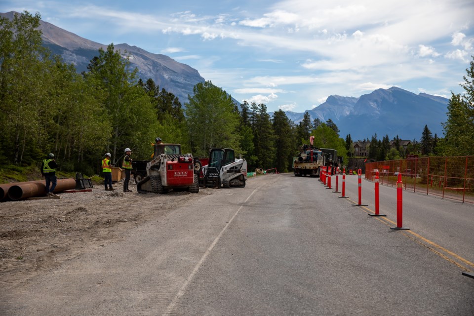
CANMORE – A stretch of road where undermining exists is getting necessary repairs to help stabilize sections of Spray Lakes Road.
Alberta Transportation is completing the work – just off Three Sisters Drive heading toward the popular Quarry Lake – after ongoing analysis showed potential safety concerns.
“Alberta Transportation has been monitoring the road on an ongoing basis to assess stability concerns. As a result, repairs to stabilize the road have begun,” said Wayne Wood, a communications advisor for Alberta Transportation, in an email.
Wood said the project cost is $962,000, noting the work is being monitored to ensure there are no environmental impacts to nearby creeks.
The work is being completed by the province. The Town of Canmore is only providing a road use permit because it is a provincial road, but within municipal boundaries.
Though possibly alarming given Canmore’s history with undermined lands, The Outlook spoke with two engineers familiar with the undermined land beneath the road who said it had never been properly assessed for undermining, so the road was built on top of shallow known workings.
They each said if the provincial undermining regulations aren’t followed, this is the likely scenario when a road is built on former coal mines without being properly studied.
Wood wrote the repairs involve drilling through the road to backfill holes that have developed over time and once completed, the section of road will be repaved.
The work means the road will be down to a single lane until completed, with speed reductions in place and people asked to allow for extra time to reach a destination.
Beneath the section of Spray Lakes Road is an abandoned coal mine, a common feature throughout Canmore. Over the last 25 years, Spray Lakes Road has seen a significant increase in vehicle use.
A 2004 report conducted by the engineering firm AMEC – now known as Amec Foster Wheeler – noted a sinkhole developed on the south shoulder in the late 1980s and was backfilled. A small sinkhole also formed during the construction of the Rundle watermain in 1993.
A ground penetrating radar survey was completed by Alberta Environment in 2000 as part of a mining mitigation program and showed the potential for cavities below the road, according to the report.
It led to preliminary borehole drilling in 2002 by Norwest Corporation and annual assessments by Alberta Transportation beginning in 2003.
“Maintenance personnel should perform frequent, detailed assessments of the road surface condition,” the AMEC report recommended. “Personnel should walk the road in this area on a weekly/monthly basis to check for any signs of cracking or subsidence that may develop. If any are noted, AT geotechnical personnel should be notified immediately. AMEC recommends that a field “checklist” be developed in order to ensure that the necessary observations are made in a recorded, repeatable manner. A field checklist will also help to ensure a consistent approach to inspecting the site.”
In recent years, the inspections and call-out reports have been completed by the engineering firm Klohn Crippen Berger.
The Klohn Crippen Berger 2017 report showed the coal mine workings were across the highway, about 40 metres wide and crossed the highway over the length of 80 to 100 metres. It noted downhole LiDAR camera, maps, geophysics, topographic survey and InSAR – a satellite-based ground deformation monitoring system – are regularly used.
A 2017 letter from Gerry Stephenson to Chris Grapel, the senior civil engineer on the project for Klohn Crippen Berger, included additional mapping and mine information, photographs and background on the four mine seams in the area.
“It is the section of shallow No. 2 seam workings above the Old Level which extend under the Spray Lakes Road at the location you are working on. Vertical section C also shows some workings and levels in the other three seams but is indeterminate as to the extent of the workings towards the surface. For this information we should rely on the mine maps.”
The mines in Canmore were open from 1886 until closed in 1979.
The threat of undermining is very real for the mountain town as much of the lands such as Rundleview, the Homesteads, the Peaks of Grassi, Stewart Creek, Three Sisters Ridge, the WorldMark Hotel, portions of Three Sisters Creek, the Cairns on the Bow and the Quarry Lake area are above former mines.
More than 1,000 homes in Canmore are built on top of undermined lands, successfully using mitigation efforts to ensure construction was safely done.
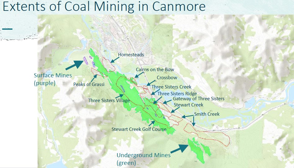 A map showing the undermined lands in Canmore, including areas that have been developed on undermined property.Handout
Detailed use of LiDar and 3D mapping during the rejected Three Sisters Village and Smith Creek area structure plans showed about 300 kilometres of undermining with mine tunnels in the town.
The 2010 Drygas Gate sinkhole beneath a municipal pathway formed near the B14 airshaft, which was created to access mine seams No. 4 and No. 3 of the No. 4 mine in 1938. The sinkhole, though, wasn’t specifically because of undermining, but due to an irrigation line that broke.
The Three Sisters parkway also had a watermain leak in 2004 that led to an erosion of the road.
The Alberta government created its undermining regulations in 1997 to address concerns from the 1992 NRCB decision that permitted future development on the lands now owned by Three Sisters Mountain Village Properties Limited.
The regulations were updated in 2020 to have any engineering study on undermined lands be reviewed and signed by a third-party engineer prior to development. The new legislation also aligned the studies and reports with the planning process.
The changes also made engineers liable for up to 10 years – the maximum allowed under the Alberta Limitations Act – and as high as $5 million per insurance claim. The developer also has a similar $5 million per claim, but for two years. The province’s Engineering and Geoscience Professions Act also has all professional engineers be responsible for their work to accepted standards.


