
CANMORE – The creatively named creeks known as X, Y, Z, situated above the Peaks of Grassi neighbourhood, pose an “acceptable” risk to life should any of these steep creeks flood in the future.
That was the conclusion by BGC Engineering, which completed an in-depth analysis and detailed assessment of each creek as part of the Town’s Mountain Creek Hazard Mitigation Program.
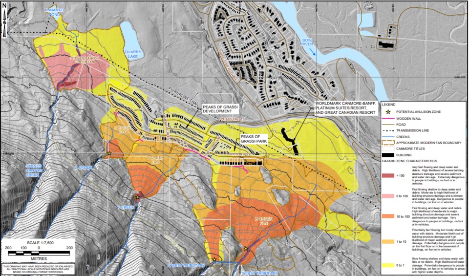
Matthias Jakob, the principal geoscientist with the engineering firm, provided council with a thorough overview of the study on Jan. 22, highlighting the hazards and risks associated with each creek, as well as providing strategies for mitigating the risks.
He told council that under the right conditions each creek is capable of a debris flood or a debris flow, which could damage houses in the neighbourhood, however how much damage depends on the location of the house, as well as the duration and intensity of the storm.
According to the study’s life-loss risk analysis, in almost every scenario the risk of a fatality was less than one person even in the event of a 1,000 to 3,000 year storm.
“Life loss risks on all the studied creeks are either tolerable, or in the case of Z Creek very near to tolerable,” said Emily Moase, a geological engineer with the firm.
“The risk assessment identified the individual risk at Z Creek right at that tolerable and intolerable threshold, according to the targets adopted by Canmore, but the group risk is acceptable.”
She said the estimated economic damages in the event of a flood of that magnitude is also significantly lower than larger creeks, such as Cougar Creek, which burst its banks in 2013 and damaged about 40 homes.
According to Jakob, a major difference between the damage caused by Cougar Creek and X, Y, Z creeks, was the duration and intensity of the rain event in 2013.
“The so called time of concentration, which means from the moment the rain drops hit the upper watershed to the time it zips by the fan apex, is very, very short, so for those small watersheds the short duration intensity is much more critical in causing a debris flood, or a disaster, than how much it rains over the course of a day or two. ” said Jakob.
“That is the very reason why during the 2013 event there wasn’t as much damage as compared to the much larger creeks, and that’s important because it would be very easy for members of the public to conclude that given that this was a multiple hundred year storm, as it was publicized widely, that it didn’t do much to these creeks and therefore nothing could happen – that’s a fallacy.”
Another important difference between Cougar Creek and the X, Y, Z creeks is that the Peaks of Grassi neighbourhood is built along the lower edge of the alluvial fans, greatly reducing the risk of a debris flow, or a debris flood, reaching homes.
“The development as you can see is on the alluvial fans of those three creeks, however on the distal parts, the further part, and that’s of course good news; very different from Cougar Creek where development encroaches all the way to the fan apex and therefore the impact forces are lower” explained Jakob.
According to a composite hazard map, the fan boundaries barely skirt the houses on Wilson Way, however in the case of a 1,000 to 3,000-year event overland flooding could still reach nearly all of the houses in the neighbourhood, causing water damage.
“We’re talking about ankle deep water and we’re talking about water velocities that you can walk away from,” said Jakob.
To mitigate the risks, Moase said there are two different ways to reduce the hazard: active measures and passive measures.
Active measures include designing and engineering physical structures, such as the debris net at Cougar Creek. Passive measures involve softer actions such as updating land use bylaws to reflect steep creek hazards, or implementing emergency preparedness plans.
For example, prior to the 2013 flood the Town installed wooden diversion walls behind the homes on Wilson Way to deflect the flow of debris and water after a flooding event in 2012 affected several houses.
She said the wooden walls proved extremely effective in 2013 and recommended reinforcing the walls and adding new ones or making them taller in some areas.
“In 2013, the wall that was constructed came to within 20 to 30 centimetres of being overtopped by flood water moving on the upstream side of that wall, so putting in a little bit of effort to potentially raise the height of that wall could reduce the risk in that area,” said Moase.
In each case, she also recommended the Town educate homeowners about the steep creek hazard in their neighbourhood and ensure people are aware of the emergency response plan.
Echo Canyon on the other side of the valley above the Bow Valley Riding Association stables was also part of the study.
According to the report, the creek is also susceptible to debris floods and debris flows, however because the majority of the development on the alluvial fan is horse paddocks, the risk to life is low.


