
KANANASKIS COUNTRY – When it comes to navigating the trails of Kananaskis Country, the province and local user groups say relying solely on crowd-sourced trail apps is not the way.
Alberta Environment and Parks (AEP) turned to social media on Oct. 5 to advise trail users against dependence on apps like AllTrails to plan their trip, which host user-generated reviews of mapped trails around the world.
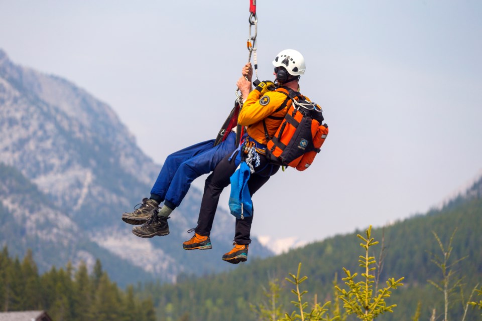
In K-Country in particular, the province said the Kananaskis Country Public Safety (KCPS) team has responded to “many incidents caused by unreliable information from the crowd-sourced app.”
As of Oct. 15, KCPS had responded to 281 calls from the start of the year. The group responded to 402 calls in the same time frame in 2021.
The most common call year after year, according to KCPS, is for lost, missing or overdue parties. Subsequent responses can range from less than an hour to multi-day searches.
Friends of Kananaskis Country co-chair Derek Ryder, who is also a wildlife ambassador for Bow Valley WildSmart, spends significant time at trailheads in the area talking to people about wildlife safety before they venture off into the wilderness.
He said he would not be surprised if most of those calls were due to visitor unpreparedness with the number of new people to K-Country identified in AEP’s visitation numbers in recent years. Although, Alberta Parks' preliminary estimates indicate visitors are down in 2022 after a record 5.3 million people visited in 2020.
“The number of people that will come up to me and ask me questions about where they are and where certain trails are … they don’t know what they’re doing, they don’t have any way to communicate or navigate without their cellphone and we have little to no cell reception,” said Ryder.
“We have accidents in K-Country because we have accidents waiting to happen. So much of it is entirely preventable if people did better research.”
While the convenience of AllTrails is appealing and useful, it does not always paint the entire picture of a hike, scramble, trail or route, or all of the above, that one might undertake.
There are hundreds of trail profiles throughout Kananaskis Country on AllTrails, in Bow Valley Provincial Park, Peter Lougheed Provincial Park and Spray Valley Provincial Park. Most are briefly profiled with the length, elevation gain, route type, a map, and a brief description followed by other details like weather forecasts, and user submitted photos and reviews.
Scattered between generic reviews of “Good trail, easy to follow, quite busy,” and “Great day,” are some more useful comments that share information pertaining to current trail conditions or recommended gear.
Still, it does not compare to a trusted guidebook, a laminated topographical map, satellite images and checking official Alberta Parks trail reports, according to Ryder, KCPS, AEP and many reviewers of the app.
One app user who said in an Apple Store review that they live in the Canadian Rocky Mountains, likened AllTrails to Wikipedia in their review. Useful, but not always accurate.
“I know most novice-intermediate hikers rely on this app as their primary (and often their only) source of information,” the user, identifying as PollyBPolly, wrote. “The information on this app often leads to novice and intermediate hikers taking trails way beyond their current capabilities.”
The user added over the last few years, they have been trying to do their “small part” in editing trail descriptions for hikes in their area. The edits include important information like trail markings, recommended gear and clearly distinguishing a scramble from a hike and further detailing the grades of said scrambles.
But the algorithm of the app is such that all reviews, regardless of how valuable to the reader they may be, are soon buried by newer, often less useful comments.
“I have found my edits are either soon replaced by, or not published at all in favour of keeping trail descriptions including such valuable information as: ‘This hike is literally so nice and fun, there’s even a waterfall!’ or ‘It’s hard but the view from the top is worth it,’” wrote the user.
Data that is not properly curated is not an uncommon sight on the app, commonly referred to as AllFails by users who find themselves misled by its guidance.
In a statement to the Outlook, U.S.-based AllTrails head of communications Meaghan Praznik said AllTrails recently conducted a full review of the Kananaskis Country trails listed in the app and confirmed all their information is current.
"Through our dedicated in-house integrity team and feedback and real-time updates shared by our community of users, we are able to maintain accurate and up-to-date trail pages," said Praznik.
The level of scrutiny being applied is not sufficient enough, however, to prevent a scenario of someone inexperienced being misguided and finding themselves suddenly route-finding or scrambling a mountain, said Ryder.
The second most common call for KCPS is for minor injuries, which tend to occur during a wide range of activities like mountain biking, hiking and scrambling.
“You just don’t have that level of information in AllTrails,” he said. “It’s oversimplified, it’s not curated, and in a lot of places, it’s just factually wrong.”
Ryder said he often runs into people chasing the latest trail to go viral on social media, not knowing more than how to get there – if they even make it that far.
“It’s the unpreparedness that is the frightening part, and the degree of unpreparedness," said Ryder. "The number of people out there that don’t know what they’re doing, aren’t prepared and don’t have the right gear is off the charts.
“It is really, really scary when you see people out in the middle of nowhere and it’s 33 degrees Celcius, and they’ve got one little 500-millilitre bottle of water on a 12-kilometre hike up a mountain they heard about while chasing the ‘gram.”
In 2017, Friends of K-Country and Kananaskis Country Public Safety co-authored a six-part series on safety in K-Country. Topics include knowing your route, what to wear, what to carry, what to eat, what to think about while outdoors and “what to do if everything falls apart and you need help.”
The series is hosted on the Friends of K-Country’s website, where they have a myriad of other safety, camping, and trail planning resources, with new content added every week.
In an email to the Outlook, Bridget Burgess-Ferrari, a communications advisor with AEP, said the problem of trail users being led astray is not exclusive to AllTrails. It’s an issue with any crowd-sourced trail app, AllTrails just happens to be one of the most widely used.
“Applications like AllTrails, Gaia GPS and Google Maps are helpful tools containing useful information and reviews; however, they can be unreliable,” the email from AEP stated. “When planning a trip, Albertans should consult multiple sources of information.”
Such resources include guidebooks, Alberta Parks official trail reports, satellite images and topographic maps. Attempts to interview a member of KCPS were unsuccessful before press time.
A satellite phone or messenger is also recommended as cellphone service is unavailable in many parks, including much of K-Country.
“Levels of difficulty can be subjective based on experience and conditions can change suddenly. Research and planning are essential to stay safe while exploring across the province,” the email stated.


