
Many Canmore residents’ memories of the 2013 June mountain creek flood experienced by the community may be fading after four years and a summer of smoky skies and hot weather.
But for Andy Esarte, Town of Canmore manager of engineering services, the business of steep creek hazard and risk assessments, as well as short term and long term flood mitigation, is an everyday concern.
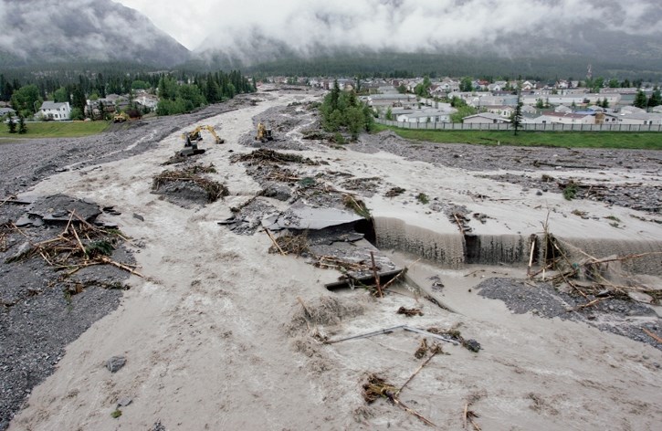
In July 2016, the Town of Canmore submitted its application to Alberta Environment and Parks and the Natural Resources Conservation Board for proposed steep creek flood mitigation on Cougar Creek – a 29.85-metre tall and 45-metre wide debris retention structure.
The application included a 1,200-page environmental impact assessment report, and has been under review ever since, with one request for additional information made in December and provided by the municipality this past July.
Esarte provided an update on flood mitigation at the September Bow Valley Builders and Developers Association (BOWDA) luncheon, including how hazards related to bodies of water have been historically calculated, and the change in approach Canmore is taking to protect its community.
“For the past century, North Americans have continued to develop intensively in flood plains,” he said. “After all, there was a sentiment in the 20th century that we could engineer ourselves out of any challenge and these engineering projects resulted in tens of thousands of dams and hundreds of thousands of kilometres of levees.
“This included the levee system built by the province in Canmore in response to the 1974 flood. It was built to the standard that has come to be known as a one in 100 year flood.
“This one in 100 year approach continues to be the current river policy today in Alberta.”
While Alberta Environment works on an updated flood hazard map for several rivers in the province, the current map shows floodway and flood fringe areas for a Bow River flow of 860 cubic metres per second in Canmore. A look at Cougar Creek on the map shows a thin flood zone in the middle of the creek and a flow rate of 19 cubic metres per second, a trickle compared to the flow rate estimated to have been 80-110 cubic metres per second (at the Elk Run culvert) experienced in 2013. The Bow River at Canmore peaked at 550 cubic metres per second during the flood.
Esarte said there are several shortcomings with designing flood mitigation policy using only a single probability occurrence. Only looking at one possible flood scenario limits the ability to understand the full nature of the hazard and, as a result, how much risk there is for the community. The current policy also only looks at clear water flow, and does not consider complex processes involved in debris flows and debris floods on steep mountain creeks.
“Another major shortcoming of the policy is it does not consider the amount of development and the amount of people we are putting at risk behind this protection,” he said. “As we continue to intensify development, we need to determine if the levees built in 1974 are adequate protection for our community considering we have had significantly more development than the 600 houses that were protected at the time (it was built).”
“It was all these shortcomings of policy that led to the impacts of the 2013 floods in Canmore and it is certainly going to lead our community and other communities to worse flood events if we do not alter our approach.”
The hazard-based approach looks at possible flood scenarios that might happen, whereas a risk-based approach analyzes how much human life is at risk, as well as infrastructure. The EIA’s preface also points to the limitations of using a hazard-based approach to protecting community and infrastructure.
“The floods of 2013 demonstrated the limitations of hazard-based mitigation for protecting Canmore from debris flows and debris floods generated by our steep mountain creeks,” stated the EIS preface. “Lacking adequate mitigation for the magnitude of this event, tens of millions in losses were experienced, highways and the railway were severed, and public and emergency response teams were put at risk.”
Four years after the flood, the municipality has completed detailed hazard and risk assessments for Cougar Creek, Stoneworks Creek, Stone Creek and Three Sisters Creek. Council also adopted a steep creek policy in 2016 that limits development in high and moderate hazard areas.
The assessment of the steep creeks includes more than just a single return period for a flood event. Esarte said the full range of hazards are considered and while the 2013 Cougar Creek flood was a rare event, larger and more significant debris flood events could occur. The Town even has an interactive map on its website (www.canmore.ca) that shows the hazard for the entire community based on return rate ranges reaching a one in 3,000 year event, along with all the reports and assessments completed so far.
“Risk assessments help council determine what, if any, additional mitigation is required to make our community acceptably safe and protected,” he said. “In the case of Cougar Creek, significant structural mitigation is needed. The risk to residents and property at present is extreme.”
As for the debris flood retention structure proposed for the Cougar Creek watershed, the price tag sits at $48 million, with Canmore contributing $4 million and the rest of the funding coming from provincial and federal governments. Esarte said the structure would protect the community from an event of equal magnitude to 2013 and provide some protection for even larger floods.
“We are hoping to be able to break ground next year and will likely see a 30-month construction process to get the project built,” he said, adding first the application to AEP and NRCB, including the EIA, must be approved.
As for the other creeks, Esarte said mitigation plans have been prepared for them, developed after the detailed risk and hazard assessments were completed.
“We are anticipating working with the province to get those projects funded over the next 10 years,” he said. “Those projects are also expensive, but he hazards are a lower order of magnitude than Cougar Creek, so they also cost a fraction of Cougar Creek.
“When the hard work is done, which there is still quite a number of years of, we can in good conscience know we have protected our community for future generations.”
Meanwhile, Alberta Environment and Parks has been undertaking to update flood maps for the Bow River.
Jason Penner with AEP said the work to prepare updated hydraulic models and hazard mapping began in the fall of 2015 and is scheduled to be technically complete by the end of the year.
Penner said modelling would look at 13 different return periods beyond just the one in 100 currently used.
“The modelling tells us how high the river would get based on certain flows,” he said. “When the work is completed it will give municipalities a lot of information to go on and measure the risks for flood hazards along the river.”
The work is being undertaken for the entire length of the 220-kilometre Bow River, beginning at the boundary of Banff National Park. The actual watershed of the river is not included in the study, as it is federally managed land under Parks Canada.


