
FIELD – Parks Canada will investigate transit options for tourist hot spots in Kootenay and Yoho national parks.
The new management plans for the two mountain parks also talk about developing visitor use management strategies.
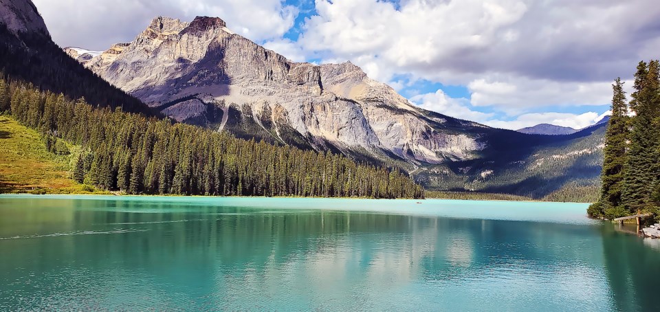
In Yoho, visitation will continue to be concentrated in several high demand areas of the park such as Takakkaw Falls, Emerald Lake and Field, and in Kootenay at Marble Canyon, the Paint Pots, the Radium Hot Springs pools and Stanley Glacier.
According to the new management plan for Yoho National Park, the feasibility for developing alternative transportation options to provide access to Takakkaw Falls and Emerald Lake will be evaluated prior to 2025.
In addition, options for establishing public transportation links between the community of Field and park facilities such as Kicking Horse Campground and Natural Bridge day-use area will be investigated.
“Visitation in high-use areas will be managed to reduce traffic congestion, prioritize public safety and provide quality experiences,” states the new management plan, which sets out the strategic direction for the park for the next 10 years.
Other popular day-use hiking and sightseeing options in Yoho will be maintained at Sherbrooke Lake, Wapta Falls, Natural Bridge, Mount Hunter and Hoodoos trails.
“Park maintenance and trail crew resources will be focused on supporting these experiences,” according to the management plan.
“The vast majority of the remainder of the park landscape will be protected in wilderness areas with low levels of human use.”
In Kootenay National Park, busy day-use areas and trailheads such as Stanley Glacier will be evaluated for ecological impacts, visitor experience concerns and parking lot congestion issues.
“Management tools such as improved parking lot configuration, trail use reservations or shuttle systems are considered in order to alleviate these challenges,” according to the new management plan.
The Canadian Parks and Wilderness Society (CPAWS) says public transportation provides a great opportunity to address traffic congestion, parking problems and experience of visitors by making trailhead access easier.
Sarah Elmeligi, CPAWS Southern Alberta’s national parks program coordinator, said getting vehicles off the road also reduces greenhouse gas emissions and noise pollution.
“But one of the things that I think is not linked into this idea of transit is that the volume of people at the trailhead may not change, and it could, in fact, increase if more people take transit,” she said.
“Transit always addresses how people move around the park, but it doesn’t address what they do when they get there and the potential impacts of having that volume of people in one place on the landscape.”
Elmeligi said she loves the commitment in the plans that visitor use management strategies will be evidence-based and in the context of achieving ecological integrity.
But, she said, the objectives and targets in the plans don’t say how that will happen.
“There’s a bit of a gap between saying how you’re going to have this visitor use use management strategy, but then the objectives and targets mostly talk about a visitor use management strategy for busy areas and identifying key markets,” she said.
The management plan for Kootenay National Park speaks to the need to mitigate wildlife mortality on roads. With Highway 93 South cutting through the centre of the park, CPAWS is worried there are no specific targets or objectives around that.
“I think that’s a big thing that’s missing, yet we know Highway 93 South is a problem in terms of congestion, and speed, and wildlife-vehicle collision mortality,” said Elmeligi.
“I know Kootenay has done quite a bit of stuff already – there’s fencing and a crossing structure by Dolly Varden – but wildlife-vehicle collisions still happen and it would have been nice to see what their next steps are around that.”
In Yoho National Park, the management plan calls for creation of a new day-use facility near the western boundary of the park, in conjunction with the Trans-Canada Highway upgrades, to serve as a welcome and orientation station for eastbound travellers.
Demand for front country camping will also be addressed at Monarch and Kicking Horse campgrounds and the potential for restoring a portion of a former campground at the western end of the park will also be looked at.
In the backcountry, the Lake O’Hara Campground will be upgraded to address the deteriorating condition of tenting sites.
The Little Yoho Valley Campground will be relocated from its existing location to a new site in the vicinity of the footbridge over the Little Yoho River. In addition, backcountry camping facilities at Twin Falls and Laughing Falls will be upgraded, but the current overnight capacity will stay the same.
The possibility of relocating the Whiskey Jack Hostel further away from a nearby avalanche path, consolidate the infrastructure footprint and improve overnight accommodation, will be investigated with partners including Hostelling International and the Alpine Club of Canada.
“If implemented, the footprint of a new facility will be within the existing Zones III and IV areas at Takakkaw Falls, or within the village of Field…” states the management plan. Overall, CPAWS says the management plans for Yoho and Kootenay are a far cry from previous ones.
“I think they’re a great improvement from the last,” said Elmeligi.


