
After living on the Columbia Icefield for nearly a month this spring, researchers with the Geological Survey of Canada (GSC) are one step closer to answering the proverbial question, “how much does that glacier weigh?”
The team, led by Dr. Mike Demuth, head of the GSC’s glaciology department, arrived on the Columbia Icefield in late April and spent several weeks collecting data they anticipate will provide enough information by the end of 2011 to allow them for the first time ever to assess changes in the icefield’s volume and mass.
This session marked the second year of a five-year project to make a complete analysis of the volume of ice contained in the 223 square kilometre iconic Columbia Icefield, from which the Athabasca Glacier, one of the most visited and recognized sites in the Canadian Rockies, descends.
Researchers flew by helicopter with their insulated science/communal tent, personal sleeping tents, food and fuel for five weeks, plus a valuable assortment of scientific equipment, to their site near the Trench, seven kilometres from the base of the Rockies’ second-highest peak, Mount Columbia.
Based in Ottawa, Demuth, Sasha Chicagov, an optical remote sensing specialist with Natural Resources Canada, and John Sekerka, an NRCan environmental chemist, along with Rockies-based glaciology technician Steve Bertollo were quickly reminded how life – and scientific research – on the massive icefield is ruled by local weather, as temperatures the first night dropped to -25 C.
Having been tent-bound for nearly a week during a storm last year, this year the team planned for a longer stay in the hope of having enough good weather to conduct their measurements.
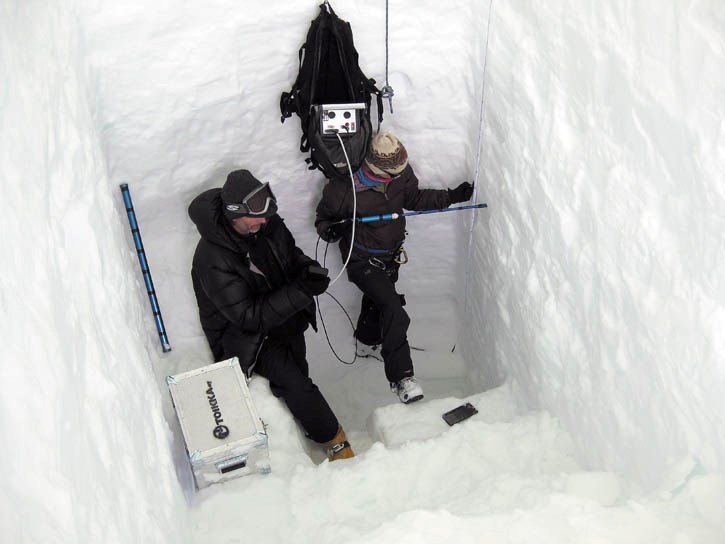
“Weather was a factor again this year,” Demuth said. “For every three days, we had one day of good weather that would allow radar glacier thickness measurements. But we had other tasks we could perform in poor weather, like digging snow pits to assess the winter mass balance.”
Digging one trench, he added, took three days.
Continuing from last year, they measured glacier thickness and conducted GPS surveys of the elevation of the icefield surface. With Parks Canada’s assistance, they are conducting surface mass balance measurements of the Athabasca and Saskatchewan glaciers right up to the top of Mount Snow Dome.
Chicagov is working to convert NTS (National Topographic System) maps from the 1980s to a format compatible with modern, extremely accurate LiDAR-created ones. Using aerial photos from both eras, he is creating digital elevation models for successive decades. Subtracting one digital model from another will reveal the difference in the height of the glacier by showing where it has become thicker or thinner over past decades.
“With this information, you could ski a line right down from Mount Snow Dome and then have a line showing the same track you took 30 years earlier, and see the difference,” Demuth explained.
A Calgary native, Demuth is an accomplished mountaineer with three decades’ experience exploring and studying glaciers in the Rockies and in Canada’s far northern regions, including Mount Logan in the Yukon.
Since his first of numerous visits to the Columbia Icefield as a climber 30 years ago, he said he’s noticed significant changes in the surface topography, as a once “inundated” ice sheet has become more conformed to the bed topography.
While comparing elevation measurements recorded in the 1980s to those taken last year reveals a great deal of down-wasting, he said, from a skier’s perspective, a historically long steady ascent toward the Mount Kitchener/North Twin col has become a relentless series of dips and rises. Monitoring such changes on the icefield that feeds rivers emptying into the Pacific, Arctic and Atlantic (via Hudson Bay) oceans is essential as the earth’s climate changes.
“Since we are quickly losing some of our long-standing glacier reference points such as the Peyto Glacier, establishing measurements over the Columbia Icefield is a critical strategy for ensuring good observations into the future,” Demuth said. “The information we gain will contribute to the assessment of climate change and the fast changing nature of our water and aquatic resources.”
Spring is the best time to conduct such research, when the winter snowfall reaches its maximum depth before it begins melting. As part of their reserach, Demuth and Bertollo skied down from the Icefield after the first week via the Saskatchewan Glacier, measuring its winter mass balance on the way.
Bertollo continued taking measurements at other sites in the Rockies and B.C.’s interior and Coast Range, while Demuth skied back up with University of Victoria student Selena Cordeau in one long 10-hour day, avoiding the serac hazard of the shorter Athabasca Glacier route. Enjoying bluebird skies the first eight hours, they navigated by GPS in a whiteout for the last two.
Cordeau’s research involves examining the large-scale weather patterns of the region and seeking layers in the glacial ice that correspond to those patterns, similar to how avalanche professionals identify a surface hoar layer and match it to the extended high pressure system that created it.
“This information will help us understand how mass balance varies from east to west and north to south, and at different elevations,” Demuth said. “Once we have that dialed, we can know that we need to measure over here, maybe over there. Conditions on the icefield are highly variable. Eventually we’ll be able to apply her data on a wider scale all over the Columbia.”
While there is never enough manpower or resources as one could wish for, Demuth said staying at the site for a longer period of time this year allowed the team to complete a lot more science. It also yielded a more intimate knowledge of the area.
“You certainly gain familiarities with the nooks and crannies of the icefield,” Demuth said. “You end up becoming a local expert of the terrain. It helps us be able to move around more efficiently, since we can figure out it’s safe over here, not a good idea to go over there.”
A longer stay also increases the amount of valuable background information complied through field notes that, once back in the lab, supplements their raw data.
While plans for next year include one or more sub-camps to facilitate dragging ground radar equipment northwest toward the Twins, the team left a mass balance stake on the summit of Mount Snow Dome as part of a citizen science project. Mountaineers who climb Mount Snow Dome over the summer months – a popular objective in the region – are asked to open up a dry bag attached to the stake containing a notebook, ruler and pencils.
“We need to know the distance between the surface of the snow/firn and a reference point on the stake, so folks are asked to make the measurement as described in the front cover of the book, and to leave a contact email so we can send an acknowledgment and a little something in return for the contribution,” Demuth said.
“Public engagement is important. We all have something at stake here and some are equipped to help out and tell the story that glaciers have been telling us for a long time. We just have to listen.”


