
Around the world, high mountain areas are places that hold much of Earth’s cryosphere, as the frozen parts of the planet are known, including snow, glaciers, permafrost and lake ice and river ice.
These high mountain areas are also where widespread changes are taking place in response to the planet’s warming temperatures. Declining snowpacks and shifts in the amount and timing of snowmelt runoff are just some of the changes happening in these areas.
The effects aren’t limited to the mountains, but have impacts on physical, biological and human systems in the lowlands downstream.
That includes the Canadian Rockies, foothills and prairies.
As was recently reported by NASA and the National Oceanic and Atmospheric Administration, which conducted independent analyses, Earth's average global surface temperature in 2019 was the second warmest since modern record-keeping began in 1880. Only 2016 was warmer. Seventeen of the 18 warmest years ever recorded have happened since 2001. Every decade since the 1960s has been warmer than the decade before.
Earth’s high mountain areas are so significant in terms of climate change impacts that last fall the Intergovernmental Panel on Climate Change (IPCC) issued its Special Report on the Ocean and Cryosphere in a Changing Climate.
Established in 1988 by the United Nations Environment Programme and the World Meteorological Organization, the IPCC is the UN’s body for assessing the science related to climate change.
The panel has 195 member governments, and hundreds of international leading experts who specialize in the different areas covered by the reports and volunteer their time and expertise to compile and publish them. Since its inception, the IPCC has released five assessment reports, and this Special Report builds on the IPCC’s Fifth Assessment Report.
The Special Report devotes a chapter on high mountain areas, with assessments on new evidence on recent changes that have been observed in the mountain cryosphere, and on changes that are projected. The chapter also looks at the associated impacts, risks and adaptation measures as they relate to natural and human systems.
Overall, the report states that in high mountain regions – where 10 per cent of humanity live – glaciers, permafrost and low-elevation snow cover are all declining. These changes have affected the amount and the timing of seasonal runoff in river basins fed predominately by snow and glacier ice, changes which in turn affect agriculture downstream.
The river systems that originate in the Rockies, including the Bow River, are experiencing just such changes.
While global temperature averages have risen by 1.1 C since pre-industrial times, during the period between 1951-2017 Alberta’s average temperatures have risen substantially more, with increases ranging from 1.9 C in Edmonton to as much as 3.9 C in areas of the Rockies.
As shared on the Alberta Climate Records website compiled by University of Lethbridge professor of geography Stefan W. Kienzle, the strongest warming has happened in the winters, with a 4 C to 5 C increase in the south of the province, and 6 C to 7 C increase in the north. Winters are becoming shorter, and with less snowfall on the ground. Summers are warming too, but at a lesser rate than winters.
But while the global average temperature increase may seem small compared to Alberta’s higher rate, it’s important to remember the phenomenon known as hysteresis, said Bob Sandford, the Canmore resident who is chair of water security for the UN University Institute for Water, Environment and Health.
“There is a lag in the system that we describe as hysteresis: the phenomenon in which changes in a physical property lag behind changes in the effect causing those changes,” Sandford explained. “The climate system exhibits considerable hysteresis in that it takes time for increases in emissions of the three principal greenhouse gases – CO2, methane and nitrous oxides to translate into warming.”
Consensus among the overwhelming majority of the world’s climate scientists is that if humans are able to slow the current global warming trend to less than 1.5 C by significantly decreasing the fossil fuel consumption that results in increased greenhouse gas levels, then the process of adapting to our warming planet will be a smoother, less volatile one.
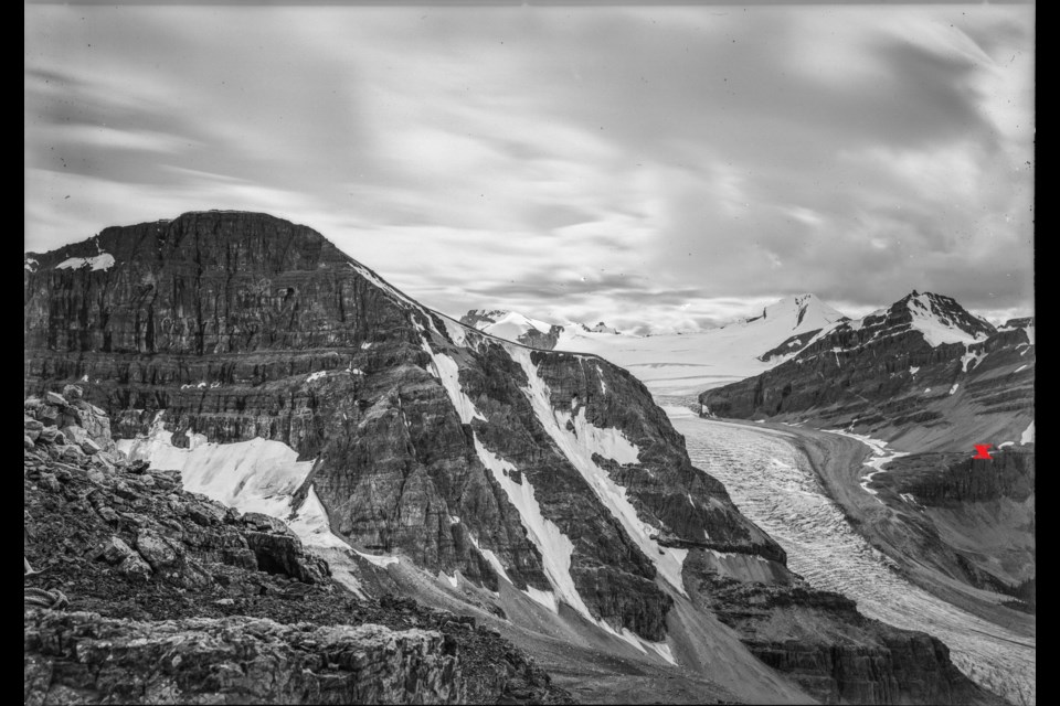
The high peaks of the Canadian Rockies form the Continental Divide, channeling water west to the Pacific Ocean via the Columbia River, and east to the Atlantic via the Saskatchewan River system. The summit of Snow Dome, located at the Columbia Icefield – one of the Rockies’ 14 major icefields – is a rare triple-apex from where meltwater also flows north, forming the Athabasca River which joins the Mackenzie River to empty into the Arctic Ocean.
Currently the Rockies harbour 741 glaciers, but 81 per cent of those are smaller than one-square kilometre, and diminishing. The major icefields and valley glaciers that are larger than 10-square kilometres make up 34.7 per cent of the total glaciated area in the province.
Peyto Glacier, an outflow glacier of the Wapta Icefield, has been studied almost continuously since American explorer Walter Wilcox took the first photograph of it in 1896. More photographs followed, and then the first scientific measurements were taken in 1923 by J. Monroe Thorington.
In the early 1960s, Peyto was one of five glaciers in western Canada to be extensively studied as part of a National Resource Council project which constituted Canada’s contribution to UNESCO’s International Hydrological Decade.
The A-frame hut constructed then continues to serve researchers today. According to a 2006 study by glaciologist Mike Demuth and colleague R. Keller, Peyto has lost 70 per cent of its mass since 1896.
One change listed in the IPCC special report outlines how glacier-fed rivers, and also summer and annual runoff have increased due to intensified glacier melt, but decreased where glacier meltwater has lessened as glacier area shrinks.
There is evidence of this happening in the Rockies, said John Pomeroy, director of the University of Saskatchewan’s Centre for Hydrology and its Canmore-based Coldwater Laboratory.
“Our research on Peyto and Athabasca glaciers show that summer and annual streamflow is increasing due to greater bare ice exposure on the glacier,” Pomeroy said. “Bare ice is relatively dark and so melts faster than firn, or snow in bright sunshine.”
While shrinkage of Peyto and Athabasca glaciers has not yet caused glacial streamflow to decline, this has likely happened with numerous small glaciers tucked in high cirques throughout the Rockies that are not monitored.
“The many unmonitored streams draining small pocket glaciers will almost certainly have declined as these small glaciers have shrunk dramatically since the 1970s,” Pomeroy said.
The Bow River’s flow, however, has been regularly monitored for decades. That flow, Pomeroy said, has decreased over the decades.
“My research has showed that August streamflow in the Bow River has dropped by one quarter since the early 20th century, and reduction of glacier and late-lying snowpatch meltwater is likely to partly explain this trend,” Pomeroy said.
A study on glacier water resources on the eastern slopes of the Canadian Rockies by University of Calgary professor Shawn Marshall and colleagues concluded that western Canada lost about 11 per cent of its glacier area between 1985-2005, with area loss exceeding 20 per cent on the Rockies’ eastern slopes. Based on current warming trends, Marshall estimates that the glacier contribution to streamflow by the end of the 21st century will drop to one-tenth of what it is now.
Meanwhile, snow accumulation in Kananaskis Country’s Marmot Creek, where Pomeroy maintains research sites, has declined 50 per cent since the site was first monitored in 1962. Warmer winter temperatures, he said, are causing changes to river flow levels.
A recent study by Jennifer R. Dierauer, Paul H. Whitfield and Diana M. Allen supported by the Pacific Institute for Climate Solutions and Simon Fraser University, which was published by the American Geophysical Union in 2018, revealed evidence of winter low flows dropping with warmer conditions in western North America’s mountains.
“The results of this study provide another line of evidence regarding the impacts of continued global warming on snowmelt hydrology, showing that an increase in winter temperatures above the 0 C threshold has a much greater impact on the hydrologic regime than just a shift in the snowmelt peak,” the report said. “Warm and dry winters correspond to significantly lower runoff and significantly longer, more severe summer low flows than cool and dry winters.”
This is part one of a two-part series exploring how climate change is directly affecting the landscape of Canada's Rocky Mountains.


