
EXSHAW – An investigation into groundwater flooding that affected homes in Exshaw earlier this year has linked the event to a higher than average snowpack, but could not rule out recently installed steep creek flood mitigation as part of the problem.
McElhanney Engineering senior hydrogeologist Roger Towsley presented the findings of his report to the MD of Bighorn council at a special meeting on Thursday (Nov. 12), along with recommendations that further monitoring and assessment would be needed to better understand the potential connection between the channel work done in Exshaw Creek with groundwater levels.
Towsley said higher than average snowpack levels, cooler temperatures in May, and warmer temperatures throughout June, contributed towards the groundwater flooding. However, without more information, he said it is uncertain what role the newly installed flood mitigation in Exshaw Creek may have played.
"The takeaway we have from this is that the primary cause for flooding in northern community of Exshaw appears to be from the melting of abnormally high snowpack in late spring and early summer," Towsley said. "Further investigation is needed to really state with any certainly whether the engineered structure on Exshaw Creek had a significant impact on flooding due to the rising groundwater levels."
The snowpack levels used for the analysis came from Little Elbow Summit. While it is located 40 kilometres away from the community, Towsley said it was thought to be the most relevant data set and that is why it was used.
The data showed higher than average levels between the end of December, when the Rocky Mountains experienced a major snow event, to mid-April when the spring melt began. Towsley said groundwater levels began to subside in early July, one-to-two weeks after the snowback disappeared.
Towsley said excavation of Exshaw Creek causing increased "localized infiltration" is a possibility. However, the melting snowpack had a major effect on the groundwater levels.
He said the existing monitoring system – a network of wells in the hamlet – are located in the eastern part of Exshaw, not near the creek. Additional monitoring would be needed in the future to better understand the relationship between the creek and the groundwater table levels during the spring runoff.
"We did observe channelling from the creek into the subsurface in the eastern creek bed," Towsley said. "But we do not know where that is exactly ending up, or where it is going."
Towsley recommended the MD develop a work plan to evaluate the flood mitigation structure; as well as modelling of the groundwater system; and continue and expand the groundwater monitoring network. That would also help measure the effects of the Bow River and the sediment pond on groundwater levels.
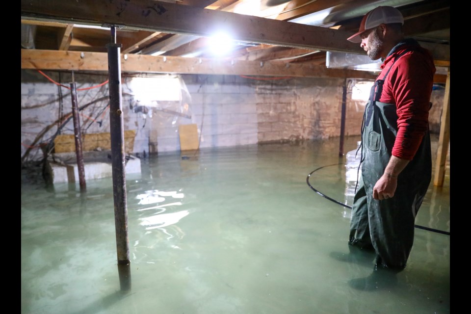
Homeowners along Mt. Mcgillvary Drive and Pigeon Mountain Drive areas in the eastern portion of the hamlet experienced significant groundwater flooding levels in May and June, while municipal infrastructure at the lift station and sewage lagoon were also affected.
Dozens of homeowners saw basements fill with up to 50 centimetres of water, which had to be pumped into the roadway and monitored 24/7 throughout the event.
Prior to the spring freshet, when the snowpack begins to melt in the spring, major infrastructure work was completed on Exshaw Creek to install steep creek flood mitigation, based on hazard and risk assessments conducted after the 2013 flood event.
Many residents questioned whether the new channelling played a part in the high groundwater levels they were seeing in their homes. Some reported seeing the water in the creek subside into the ground towards the eastern end of the hamlet.
Councillors Paul Ryan and Lisa Rosvold expressed frustration that the hydrogeologist report was not able to answer the questions they hoped it would.
"I find it hard to accept this, because I know our residents were looking to this report for solutions – as was I," Rosvold said.
Council direction was for a study to be conducted to determine the cause of the high groundwater; if the recently completed mitigation on Exshaw Creek was the cause; and what could be done to mitigate the situation.
"I have the same four questions we had when we commissioned McElhanney in the first place," Ryan said. "There are partial answers in here and there is a lot more work to be done."
The report was unable to make recommendations on possible mitigations for the situation. Towsley said if there were easy solutions, he would have presented them.
"Until we really understand the groundwater flow regime in that area a little bit better, there is no way to really answer that question," Towsley said with respect to mitigations. "We need to do more work. We need to understand the flows from both Jura and the Bow River and the interactions of those with the community, and also from the structure itself and Exshaw Creek."
However, he said a possible short-term solution next spring could include some form of groundwater extraction and look at discharging it in Jura Creek. But he added it is possible that the groundwater level volumes would be so high that this possible solution may not actually mitigate the problem.
Administration is preparing a review of the emergency response to the groundwater flooding event, which will return to council when complete.
"What we have learned is that the June, 2020 groundwater levels were not a statistical anomaly," Chief Administrative Officer Robert Ellis said in a press release. "We need to be as prepared as possible for the next high groundwater event, whether it is caused by an exceptional snowpack, or high precipitation levels, or the Bow River."
Reeve Dene Cooper suggested the next steps include a discussion at council's upcoming strategic planning sessions.
"I don't think we can hit a home run at strategic planning, but I do think we can flush out some of the frustrations, concerns, priorities and possibilities in that conversation," Cooper said.
The final report from McElhanney used groundwater hydraulic testing to confirm the presence of highly permeable underground materials in the area affected by groundwater flooding.
Towsley pointed out the area under scrutiny is situated on a flood plain, surrounded to the west by Exshaw Creek, to the east by Jura Creek and the Bow River to the south.
Towsley said the groundwater flow rates in the area are significant and the work needed to understand the effect the changes in the creek had on groundwater levels within the complex hydrologic system would be challenging.
The methodology for the study included use of three existing wells and installed four new monitoring wells at the base of Exshaw Mountain. Towsley said he was able to measure the groundwater level every 10 minutes from May 14 to Sept. 17.
"I consider that to be fairly high-resolution data," he said. "These graphs are fairly comprehensive in what they captured over that period."
The levels show rapidly rising levels in mid-May, with a pause on May 28. The peak was on June 4, but levels remained high throughout the rest of the month. It was the same time period of the surface flooding in the community. The levels began decreasing after June 30 until mid-September.
Rainfall, on the other hand, was below average for the same period of time.
"Between May 21 and June 5, there was very little rainfall," he said. "About five maybe eight millimetres of rain occurred here ... and rainfall continued to be below average for the remainder of the season."
- RELATED: Provincial reports points to rainfall and snowmelt as cause for Exshaw groundwater flooding
While homeowners in the community felt it was an extraordinary event, an application to the province's disaster recovery program to provide assistance to residents of the hamlet affected was denied. The province did not consider the event to be "extraordinary" or "widespread."
However, the MD did receive $50,000 from the program to offset its emergency response costs, which currently total $113,000.
The steep creek flooding mitigation for Exshaw Creek was completed in May this year for a total cost of $10.8 million. Work continues on Jura Creek mitigation, with $2 million already spent in phase one of the project and work set to continue with a cost $3.8 million in phase two in 2021.
The work to mitigate the mountain creeks is a result of the 2013 flooding event that inundated communities that developed on alluvial fans adjacent to these types of waterways, including Cougar Creek, Three Sisters Creek, Stone Creek and Heart Creek.
Go to the MD of Bighorn's website to download the full report.


