
BANFF – Banff experienced its sixth warmest December on record.
Weather experts with Environment and Climate Change Canada say it was a warm month overall, with the warmer trend expected to continue throughout winter due to El Niño.
“The month of December for Banff was the sixth warmest on record out of 135 years of data,” said meteorologist Justin Shelley.
“Banff was actually 5.2 C degrees warmer than normal on average, and throughout the entire month.”
For Banff, the mean monthly temperature for December is minus 9.2 Celsius, whereas December 2023 was minus 4 C.
“It’s certainly quite above normal,” said Shelley, adding other parts of Alberta were even higher than that.
“Calgary, for instance, was 6.9 C above normal, which was actually the warmest December on record for Calgary.”
While warmer than usual, there were no daily record temperature records set in December.
For reference, Shelley said the daily record for New Year's Eve was 8.9 C set in 1958, but Dec. 31 2023 was 1.7 C.
“It looks like we were about five or six degrees or more below those daily record thresholds,” he said.
As for precipitation, Shelley said it has been relatively dry in Alberta, except for a little pocket in the southwest part of the province.
“Calgary and Banff and Pincher Creek are the only areas where it actually saw slightly above normal precipitation for the month of December,” he said.
According to ski hill websites, 247 cm of snow has fallen this season at Lake Louise, 212 cm at Sunshine, and 149 cm so far this year at Mount Norquay.
According to the Environment and Climate Change data, Banff saw 37.2 millimetres of precipitation in December compared to the average of 33.2 mm.
“Likely a portion of that would have been rain,” said Shelley.
El Niño is a climate pattern associated with warming of the ocean surface temperatures in the central and eastern tropical Pacific Ocean, which can significantly influence weather patterns and ocean conditions worldwide.
In Canada, typically, El Niño winters see an influx of mild Pacific air across most of Canada rather than harsh Arctic air, resulting in a lack of consistent, severe-cold weather.
“We are in a El Niño pattern globally and so typically during these El Niños we see these warmer than normal and drier than normal conditions,” said Shelley.
“This year, in particular, is actually what is classified as a strong El Niño, which is just based on the temperature anomaly thresholds. Those anomalies through this part of the province are stronger.”
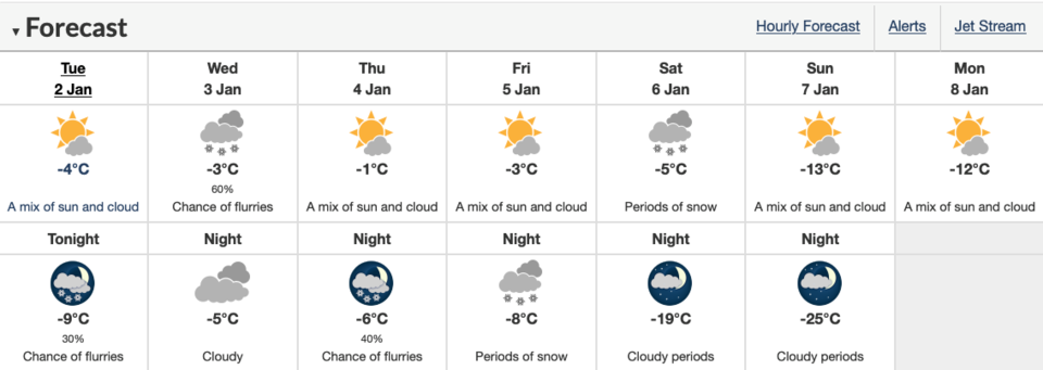
Moving forward, at least in the short-term, Shelley said the warmer temperatures are expected to persist, but will begin to drop off by the weekend and into next week.
“They will actually be near or probably below normal for this time of year … so we’re going to see a bit of a shift in this pattern,” he said.
“The average for the Bow Valley, for instance, is minus 2 C for daytime highs, and it's possible by next week those daytime highs will be in the single-digits, maybe minus 10 C range.”
Shelley said not much is expected in the way of precipitation in the short-term, though they are tracking a system that could bring snow along the foothills on the weekend.
“It looks like possibly five to 10 cms in some parts of southwestern Alberta could fall between Friday and Sunday, so there might be some good news there,” he said.
“And then temperatures look like they're going to sort of plunge into the deep freeze, especially relative to what we have been accustomed to so far this winter.”
The El Niño pattern is still forecast to persist through the winter period.
“I'm not sure in terms of the relative strength, whether it's going to maintain itself as a strong El Niño or just be a regular El Niño,” said Shelley.
“The confidence is relatively high in terms of having warmer than normal conditions persist for the rest of the winter,” he added.
“In terms of are we going to see those five, six, seven C degree anomalies again for January or February, it’s too early to say.”
In terms of precipitation for the rest of winter, Shelley said there is not a strong signal in the forecast models to predict above or below normal snowfall.
“All we can say is, on previous El Niños, we typically see, for the most part, drier the normal conditions,” he said.
