
CANMORE – To tell any story of Canmore, one has to start with coal mining.
Originally founded as a railway town, almost a century of mining saw millions of tonnes of coal removed from 1886 to 1979 and helped define the characteristics of the community.
Despite the last mine being closed more than four decades ago and Canmore now better known as one of Canada’s top tourist spots, the heritage of coal mining still plays a role in shaping the future of the community.
One of the most contentious issues voiced by residents during the public hearing for Three Sisters Mountain Village area structure plans were concerns over undermined lands and what would happen if they were developed.
In the nearly three decades since the 1992 Natural Resources Conservation Board (NRCB) decision that established development would happen on the lands in one form or another, the province has twice issued undermining regulations for the region.
The first in 1997 to address concerns from the NRCB decision and an updated version in 2020, following advocacy from the Town of Canmore, TSMV and residents.
The NRCB decision stipulated the lands were permitted for urban land use, but necessary assessments were to be done before any homes began popping up. They also recommended the creation of an Undermining Review Group, with engineers from the Town, the developer, the province and locals with mining experience.
“The Board would prohibit development on the undermined project lands until a comprehensive assessment satisfactory to the Town of Canmore has been undertaken,” the decision read.
The Undermining Review Group recommended in the 1990s a golf course on the lands was the best option, due to the hazards such as vertical and steeply dipping coal seams and the complicated nature of the friable coal in Canmore.
A report from the late 1990s by Norwest Resource Consultants, who had local Gerry Stephenson as one of the three principals, also emphasized developing a golf course on much of the lands, opposed to residential, commercial and industrial sites.
Stephenson was the former chief engineer and assistant general manager for the Canmore mines. He passed away in 2019, but was vocal in opposition of any development occurring on the lands where significant undermining had taken place.
He was vital in the reclamation projects for Quarry Lake and Canmore Creek. During the public hearings, Stephenson was referenced dozens of times and his steadfastness on no development on undermined lands has been taken on by many in the community.
Raymond Haimila, who was part of the Undermining Review Group for most of the first year, said he remembers the engineers involved planning to do a site tour of certain areas when Derek Steele, a geotechnical engineer from Dames and Moore Engineering who was advising the Town, said no one would be allowed to go because of the uncertainty of the ground.
They equally warned of concerns with sag subsidence, when land over former mines begins to subside into the earth as mining seams beneath collapse and shift the ground. Haimila said pit subsidence, which can cause a sudden collapse, is also a risk in the area.
“You can get pit subsidence from anywhere on that map and that’s one to two kilometres wide and nine kilometres in length. That’s a lot of area.”
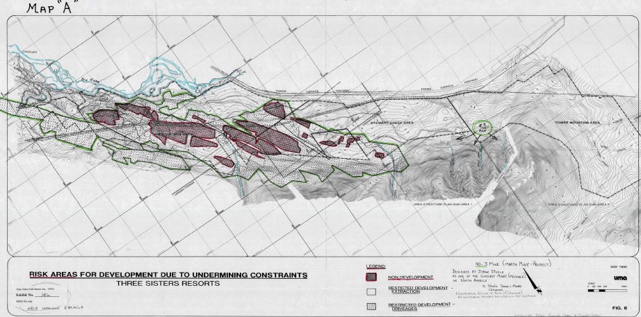 A map of the Three Sisters Resorts from the 1990s show areas that aren't recommended for development.Handout
Haimila, a third generation miner, stressed the municipality should contract its own geotechnical study to review the potential for development of the land.
He also pushed for the Town to ask Wood Group – who did the mining impact overview for the Three Sisters Village ASP – to remove the final three pages of its report, which includes 17 limitations that may conflict with the province’s March 17, 2020 order in council announcing the undermining legislation changes – specifically section 10 that discusses insurance.
Representatives for TSMV have said the limitations are in place since subsequent reports – ones that detail with specific areas for proposed development – are required under provincial legislation before any buildings are constructed and it would not overrule the provincial legislation.
Haimila originally wasn’t intending to become involved, he said, after being part of discussions for more than 30 years since the NRCB public hearings, but it was the limitations that had him speak at the hearing in a similar warning that he gave in 1990.
Haimila has spent extensive time researching and finding historic mining maps in the community, libraries and archives, and the Geological Survey of Canada office in Calgary. After the mines closed and the Town took over the mining office, he would go to the basement, sign out the maps for the maximum four hours, go to Cascade Engineering and have them copied before returning them.
Norbert Morgenstern, a geotechnical engineer and former professor at the University of Alberta’s engineering department, also recommended during the public hearing the municipality complete a quantified risk assessment to determine the risk of developing on the land due to the “complex coal subsidence.”
A 1999 paper by Norwest Resource Consultants, who were retained for studying the Three Sisters land in the 1990s, noted the majority of the mines in the area used a room and pillar method. The style has mined material extracted on a horizontal plane with rooms of coal being dug out and pillars of material left to support the roof.
The 2002 assessment of wildlife corridors by Golder Associates found aspects of the land was able to be developed. Golder recommended layering the land use adjacent to wildlife corridors from a conservation easement to the golf course, trails and finally development for the 2004 Resort Centre ASP.
“The advantage of having a golf course between the corridor and housing is that the golf course will act as a barrier to people straying into the [wildlife] corridor,” the report stated.
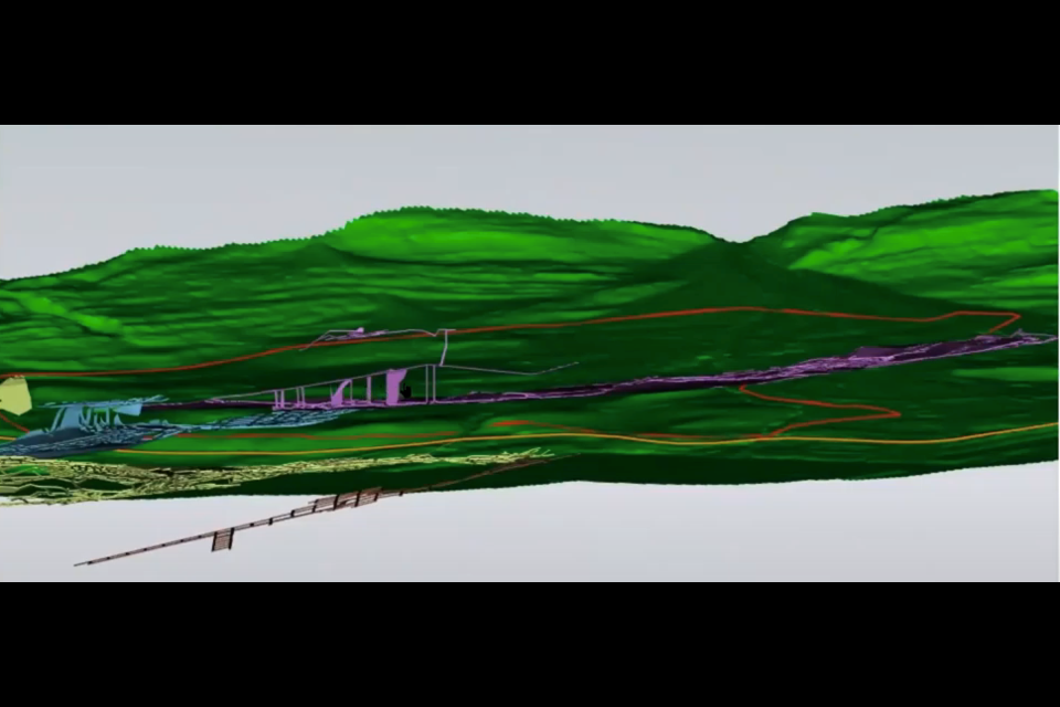
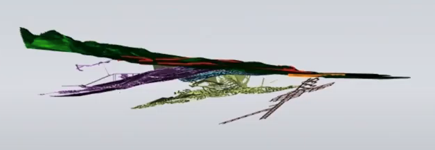
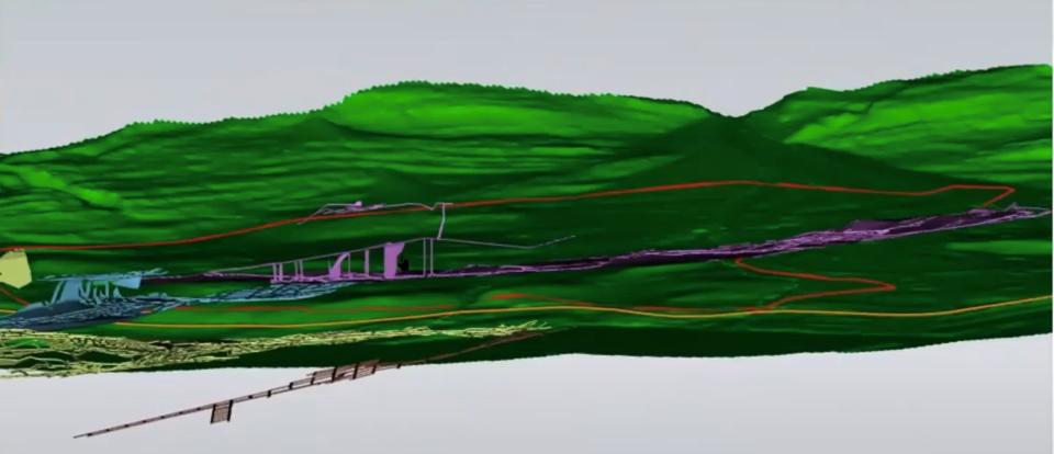 A three-dimensional image shows the undermined areas under the Three Sisters Village area structure plan.Handout
Mitigating undermined lands
As mitigation efforts and technology improved, more information on the exact mining on the lands was learned and changes to provincial legislation made the viability of development on the lands more realistic.
The mitigation method uses a paste backfill in the area where infrastructure and development is found to be safe to build on. It stabilizes the area with a cementitious element to limit the potential of future collapse and allow for construction.
The paste uses fly ash in the mix and the structural designs of buildings are also assisted in mitigating the stresses on the land created by extra weight.
The 2020 provincial undermining regulation enforced any engineering study on undermined lands to be reviewed and signed by a third-party engineer. The province’s Engineering and Geoscience Professions Act also has all professional engineers be responsible for their to work to accepted standards.
The new legislation brought in a laundry list of changes, but better defined who the developer is, gave a timeframe for registering an undermining report and added more detail on the insurance needed. It also included a higher standard of mitigation needed for underneath pathways and roads as well as utilities being equal to those of mitigation near buildings. The legislation also aligned the necessary studies and reports with the planning process.
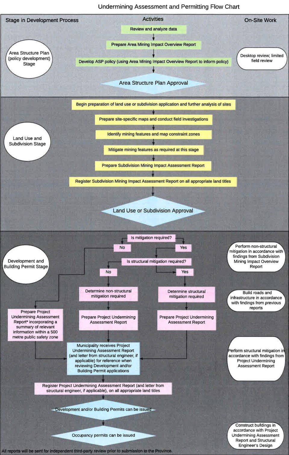 A flow chart of the process to follow for undermining reports needed during the development stages.Handout
Under the development process, a mining impact overview – which receives third-party review – is completed during the ASP stage. Wood Group completed the report and the provincial third-party approved it.
If the ASP is approved, the subdivision phase would have further analysis of proposed sites to be built on conducted and again reviewed by a third-party. The development and building permit stage would require a project undermining assessment report that is also third-party reviewed. The process would have three completed undermining studies that are all independently examined and follow Canmore's Engineering Design and Construction Guidelines.
All copies of undermining studies are also provided to the province and municipality. Once accepted, the developer is required to put them on the title of the land, letting any potential owner know the possible risk.
But just because the initial overview receives the OK, it does not mean subsequent studies will obtain the same passing marks as they become more detailed.
“With more information comes more knowledge and better understanding and better ability to determine what is possible through mitigation,” said Jim Tod, who along with Adam Coulson, were the leads for the Wood Group geotechnical study.
Chris Ollenberger, the principal at QuantumPlace Developments, said at the public hearing with the changes in the undermining policy, it’s more aligned with the planning process. Rather than think of the initial study as the final, it lays out the roadmap for future analysis.
“The report is suitable for an area structure plan. This is where we’re thinking of putting things. We have a very conservative map that says where we need to pay more attention and here’s where we need to pay less attention, according to the guidelines, and we zoned them appropriately. … This report would not be appropriate for proposing a building. The first thing Wood would say is ‘you need to do way more investigation.' There’s those layers of reports that are forthcoming that followup and make sure those questions you’re asking are addressed.”
 A three-dimensional image shows the undermined areas under the Three Sisters Village area structure plan.Handout
According to the new undermining guidelines, the engineers are liable for up to 10 years – the maximum allowed under Alberta’s Limitations Act – and as high as $5 million per insurance claim. The developer also has a similar $5 million per claim, but for just two years.
Some liability will remain for the municipality in terms of damage to Town property, such as infrastructure, roads or utilities, on undermined land. But the new laws have the province picking up the burden of any third-party claims made against the municipality.
During the public hearings, residents expressed concern over the length of the provincially legislated liability.
Ollenberger told council at the public hearing the Town could choose to turn public infrastructure into private and make it the responsibility of a homeowners association such as been done in the Three Sisters Ridge area.
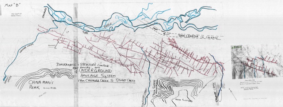 A map shows the haulage system highlights the underground workings of the mines from No. 1 mine on Canmore Creek to No. 3 mine in the Smith Creek area.Handout
Haimila asked the Town to require the developer to post a $5 million surety bond with a five-year term that’s renewable. In the 30 years since his original participation in the NRCB public hearings, Haimila has been consistent in asking for the surety bond.
The true test of the 1997 undermining legislation was the 2010 Dyrgas Gate sinkhole beneath a municipal pathway near the B14 airshaft that was created to access mine seams No. 4 and No. 3 of the No. 4 mine in 1938.
The sinkhole wasn’t specifically due to undermining, but from an irrigation line that broke on previously undermined land.
“One of the things that happened with the Dyrgas Gate shaft was it worked. I know people are unhappy about the fact a pathway collapse happened, but the intent of the engineering – are the structures far enough away, can anybody physically get hurt, is it possible for someone to fall into one – all those questions were no,” Ollenberger said at the public hearing. “The buildings were pushed back. … They made sure there was a wide safety measure for structures. The shafts in the [proposed ASPs areas] are much more well known and recognized.”
A similar incident took place in 2004 on the Bow Valley Parkway and was also deemed to be caused by a watermain leak that led to erosion of the road.
However, the Town was not protected from the liability in 2010 for direct losses since the province interpreted only third-party liability being covered. The insurance wasn’t transferred when the lands became Town property.
The province did give Canmore $600,000 in 2013 to mitigate the sinkhole, but the ultimate cost was about $1.7 million as the Town had to bear the remaining financial burden.
The new undermining regulations now legislate mitigation be done to a higher standard, but several residents at the public hearings noted if an incident due to undermining were to happen, provincial funding still comes from taxpayers though it is spread throughout a greater population.
Building on undermined land
The concerns over undermining will never quite go away.
However, mitigation efforts have been successfully used in other undermined lands in Canmore such as Rundleview, the Homesteads, the Peaks of Grassi, Stewart Creek, Three Sisters Ridge, the WorldMark Hotel, portions of Three Sisters Creek, the Cairns on the Bow and the Quarry Lake area. More than 1,000 homes in Canmore are built on top of undermined lands, successfully using mitigation efforts to ensure construction was safely done.
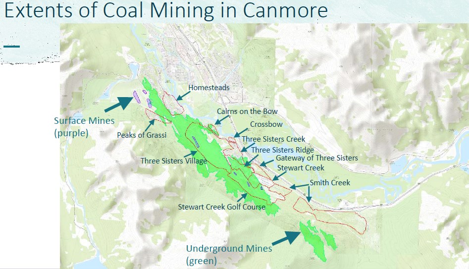 A map showing the undermined lands in Canmore, including areas that have been developed on undermined property.Handout
The area of Three Sisters Village are among the most heavily undermined, with the proposed area possibly being more than 50 per cent mined at some stage in Canmore’s history.
Undermining mitigation has proved successful in Albertan cities such as Edmonton and Lethbridge and across the country, while provinces such as Nova Scotia also has guidelines for mine subsidence in municipalities.
The United Kingdom, where an estimated 29 per cent of developed properties are near coal fields, according to the CON29M report that serves as the country’s official legal search for buying or selling on land near coal mines, also heavily uses mitigation efforts.
In 2019, the UK Coal Authority and the Construction Industry Research and Information Association released an updated 500-page guide for building on undermined lands, with the Coal Authority estimating about 15 per cent of land is near mining areas.
American states such as Iowa, Maryland and Pennsylvania have similar regulations and interactive maps to guide residents potentially buying, selling or building on undermined land. The Alberta Energy Regulator also has an interactive coal mine map for the entire province.
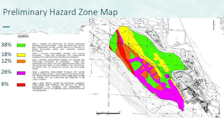 The preliminary hazard zone from the Wood Group area mining impact overview report.Handout
The TSMV submission rationale for the two ASPs stated the company that had undergone an extensive review and been accepted by the province’s third-party reviewer.
“These investigations have informed the location of land uses and open spaces within Three Sisters Village.”
The initial study developed a preliminary hazard zone assessment map that established five zones from low to high risk areas to develop on, with further studies to get more detailed information.
Identifying mine locations, though, can be troublesome.
There are historic maps, but it’s not as simple as opening Google Maps for directions. Geotechnical work saw various methods such as nearly 500 boreholes being drilled, LiDAR being flown over a 53-square-kilometre area and analyzing historic and previously mapped features were completed. It was then used to form the 3D mapping that shows about 300 kilometres of undermining with mine tunnels of various sizes between 1.5 and 2.7 metres of height.
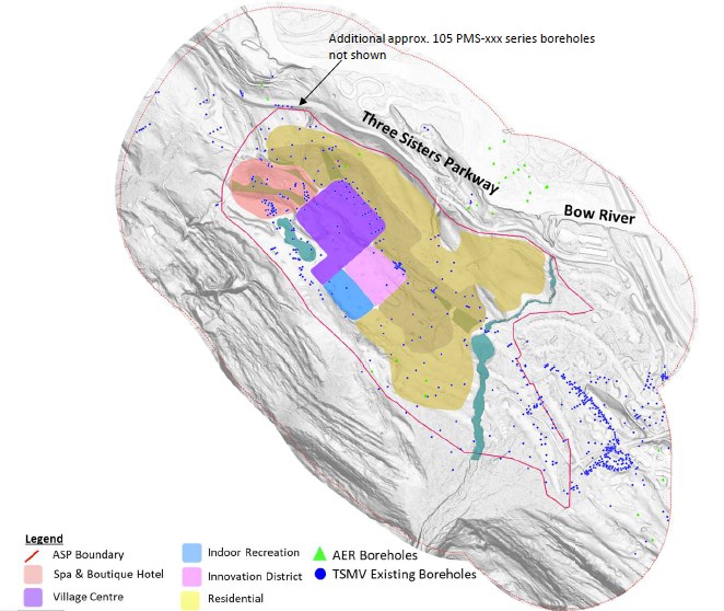 An image shows the boreholes drilled in the Three Sisters Village area structure plan.Handout
Fourteen shafts in three different mines had also been mitigated in the ASP area between 1998 and 2007, according to the Wood Group mining impact overview report.
Regardless of the decision that comes from third reading, undermining will continue to be a focus in the daily life of Canmore residents.
Despite few people from the Town’s mining days remaining, the legacy will continue to hang over the town for decades and possibly centuries to come.


