
The cost of buying out 181 homes in Cougar Creek deemed to be at high risk for future floods far outweighs the cost to build a debris retention dam in the channel according to municipal officials.
According to a presentation by manager of engineering Andy Esarte, the rough cost estimate of purchasing the homes at an average of $500,000 each would be $91 million.
Esarte said the expert team Canmore hired to consider various options was given several assumptions and one was that mitigating through infrastructure is less costly than removing homes.
“This was not thought to be an acceptable approach,” he said, adding Cougar Creek as it currently sits has unacceptable risk. “There is a risk for multiple fatalities in one of these larger events.”
Esarte said before last June sediment was seen as a nuisance and not a critical part of the process in the creek.
“In 2013, as other mountainous regions around the world before us have, we learned the hard way that steep creeks and large events can have catastrophic losses,” he said. “Within weeks of the flood, council approved a project for mountain creek mitigation.”
The work since then has focused on finding out what happened, what could happen in the future and what to do about it. That meant moving from a hazard approach for managing floods to a risk based one.
“If you look at only the first 100 years of potential outcomes, oftentimes that doesn’t mean a significant hazard,” Esarte said. “By looking at only that short term, you miss that risk.”
The recommended flood retention structure option being considered for long-term mitigation is 30 metres high, composed of reinforced steel and concrete embedded into the bedrock with a steel designed grate. A grate allows water to flow through the structure at a controlled rate, mitigating damage downstream. The design includes an area 600 to 800-metres upstream to store sediment and water in a debris flood event.
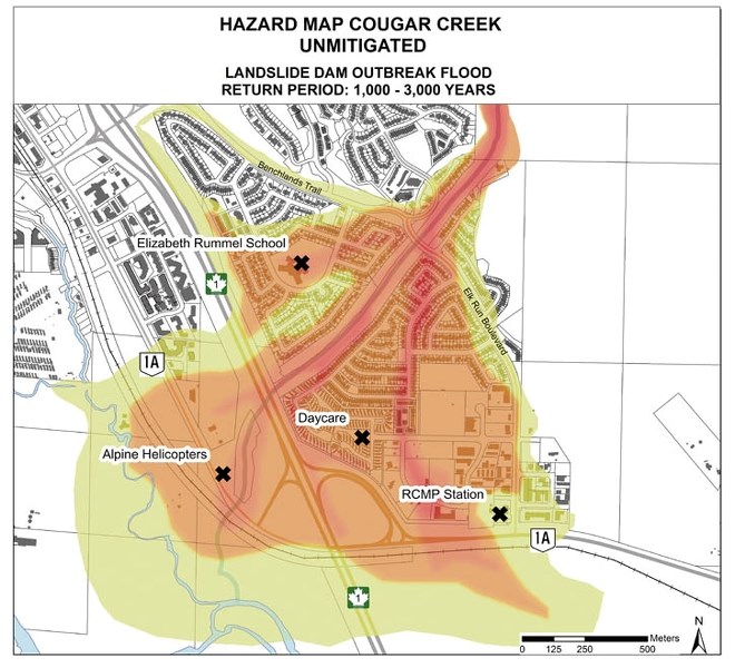
That represents mitigation for a 1,000 to 3,000 year event, rather than one designed for a one in 100 year event. That equates to hundreds of thousands of cubic metres of sediment and peak discharge of 1,000 cubic metres per second. In comparison, the Bow River in 2013 peaked at 550 cubic metres per second.
“In terms of risk reduction, this recommended option provides significant reduction for risk of loss of life, it reduces the estimated property loss and that was another metric considered in risk assessment,” Esarte said.
But there are more creeks out there with development, or development potential. Esarte said there are other mitigation options for creeks like Three Sisters and Stone creeks as they have not been fully developed.
“Cougar Creek is the largest hazard, but there is significant development on other creeks,” he said. “Fortunately, to this point, we have not done as was done on Cougar Creek and developed on both sides of those fans and so the strategies you can use in those cases are to protect one side of the fan and allow the creek and sediment and debris to spill out on the other side of the fan.
“In that way, you don’t have to capture that large volume; you don’t have to absorb those large forces, you let it naturally deposit out. The costs are an order of magnitude less than if you are trying to capture all of that, so there is an opportunity with undeveloped fans to use the hazard assessments we are creating to be able to make decisions that allow us to limit the amount of infrastructure that is required.”
The recommended option also means culverts at Elk Run Boulevard would not need replacing with a bridge at this time, according to BGC’s Matthias Jakob.
“One option was the lowermost barrier and we would have recommended the replacement of Elk Run Boulevard with a bridge for the simple reason that this very high discharge would not be lowered to a level where it would still fit under Elk Run Boulevard,” Jakob said. “Whereas for the recommended option, the idea is that in great events it captures the water that would be released in landslide dam outbreak floods.”
Landslide dam outbreak floods, Jakob said, are possible in Cougar Creek and represent the worst-case scenario for that watershed. Those types of events are catastrophic in nature and the risk assessment shows significant damage in Cougar Creek if one were to occur. There is historical evidence since the last glaciation of 13 landslide outbreak dam floods in the creek.
They result from landslides higher up in the watershed that block the creek stream and eventually break, causing large amounts of water and debris to be released onto the alluvial fan.
What’s more, Jakob said, Cougar Creek and others like Three Sisters and Pigeon have an unlimited supply of debris and “millions of cubic metres readily available.
“So as soon as you see a certain hydro-climactic threshold of precipitation it will start moving stuff and the longer the rain storm exceeds a certain threshold of intensity the more material will come down,” he said. “Not in our lifetimes, or not in the next 10,000 years, or millions of years will it ever exhaust its sediment supply.”
Jakob said there are a lot of unstable rock faults in the Cougar Creek watershed, “so we couldn’t possibly monitor them all, but we have our eyes on a few suspects and in the future we may choose to monitor some of those in particular.”
At public presentations there was praise for the work the Town has undertaken in such a short time frame to learn about what happened in 2013 and mitigate against it in the future.
However, the history of Cougar Creek was mentioned by some, like Jim Pissot, who appreciated the efforts being made, but questioned the original decision to develop.
“I have reviewed some of the documents over the last 40 years and they are actually quite embarrassing in that we knew well not to channelize meandering streams on alluvial fans at the time when it was done to Cougar Creek and due to a variety of pressures they did it anyway,” Pissot said.
Colleen Campbell brought up the same issue in relation to repair and maintenance of the debris retention structure. The estimated annual cost for sediment removal, inspection and monitoring is $170,000.
“I think the Town needs to put pressure and responsibility onto the provincial government to cough up on an annual basis to help us maintain a problem they created,” Campbell said. “They allowed (development) to happen and I think they are culpable for the ongoing costs that accrue to us as members of this community.”
Esarte said while repair and maintenance hasn’t been discussed with the province yet, the assumption is the structure will be managed by the municipality.
“The province doesn’t want to be in a position of being responsible for local mitigation,” he said. “We will have our own internal main program for all of the mitigation and we would expect that (with Alberta Transportation) being significant beneficiaries and users of gravel, they will partner with us in some fashion.”
Spring Creek Mountain Village developer Frank Kernick expressed concern that mitigation in Cougar Creek is proposed for a 1,000 to 3,000 year return period and the Bow River has a berm constructed in 1974 for a one in 100 flood.
“It was inches away to breaching,” Kernick said about the river last June. “Is there any cause for design on how to protect downtown from a 1,000 to 3,000 year flood if we are trying to protect these (Cougar Creek) lands?
“It is about where you spend your money and we have 1,000 to 2,000 properties downtown and very few people know how close we were to losing the downtown community.”
Esarte said with a risk-based approach it allows the municipality to look at different hazards and treat them equally, and in the case of the Bow River, that assessment can be done.
“I would advocate we take that approach with the Bow River as well,” he said.
The work done this year with articulated concrete mats in the Cougar Creek channel will remain as part of the long-term infrastructure. Jakob said they are designed to prevent erosion and will do that more successfully with lower water and sediment coming downstream from the proposed retention structure.
“That is another reason we want the large structure,” he said.
The structure also provides added emergency response as it can be monitored in an event and people evacuated sooner from their homes if needed.
“As it starts filling, we may start moving people out of the way,” Esarte said.
Levels at the dam are not the only thing being monitored by the municipality. Esarte said the Town is working with the University of British Columbia to have advanced notice of hydro-climactic events. There is also monitoring of snow levels throughout the region.
As for the funding mechanism for the $40 million structure – Esarte said Canmore is working with a similar formula as is used in Austria where municipalities contribute 10 per cent, or $4 million.
“That is the formula we have been trying to follow,” he said.
The remaining funds are assumed to come from the Disaster Recovery Program ($2 million), the Flood Recovery Erosion Control Program ($19 million), Alberta Transportation ($4 million) and the Alberta Community Resilience Program ($11 million).
Meanwhile, the large pile of rocks adjacent to Cougar Creek on Elk Run, said Esarte, are there to stay for now. They were ordered to construct grade control structures as part of the short-term mitigation, but the decision was made not to use them.
“Rather than construct those grade control structures in the short term, we took delivery of the rock because rock prices from the time we tendered the project to the time we made that decision had doubled or tripled in price,” he said.
Recommended option: debris flood retention structure at the debris net location; 30-metres high, 650,000 cubic metres potential water and sediment storage.
Option two: debris flood retention structure at Kame Terrace; 24-metres high; 650,000 cubic metres potential water and sediment storage.
Option three: sediment retention structure at Kame Terrace; 12-metres high; 175,000 cubic metres potential sediment storage.


