
The tides may have turned on the Verdant Creek wildfire, with no significant growth in the blaze over the past two weeks, and a new use of technology has helped Parks Canada firefighting crews gain the upper hand on the ground.
Drone technology using infrared cameras at night is a new tactic being used by fire crews to detect and extinguish hot spots along the fire’s perimeter, according to incident commander Jed Cochrane.
“Technology has come a long way,” he said. “It is really a neat story.”
Cochrane was deployed at a fire near Clearwater, B.C. in July when he came across the company Hummingbird Drones, based out of Kamloops B.C. While use of drones is not new, Cochrane said the company’s software program to detect hotspots and mapping was so impressive he recruited the four–person team to assist with the Verdant Creek wildfire.
“We give them a fire perimeter and tell them this is the area we want you to look at and they go out at night, launch the drone and it can cover a few hundred hectares,” he said. “In the morning, we get a high quality map back and it has mapped where our hot spots are and sometimes it is geo-referenced, so crews can use GPS in their smartphones to find the exact location of the hot spot.”
The use of drones to replace helicopters for surveying fire status on the landscape has multiple advantages, said Cochrane. With the drones operating at night, they don’t interfere with helicopter activity, they are cheaper on fuel, and they can get closer to the fire than aircraft.
What Hummingbird does that is different is their software scans the images the drone captures to find hot spots on the ground with greater accuracy, said Cochrane.
“The accuracy of the mapping product is one that helps us find the hot spots quite quickly,” he said. “So that gives us comfort and helps us to be really efficient.”
The use of GPS is key to that efficiency, as firefighters tasked with working the perimeter of the fire can go directly to the location pinpointed with the drone technology.
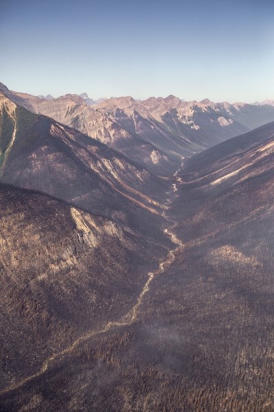
Crews going in to fight the fire encounter a variety of hazards. Cochrane said hot ash pits on the ground could be a hazard for crews walking through an area.
“The first objective of any fire line is you want to make sure where they are working is safe and there are a number of hazards on the fire line, the most significant one being the fire itself,” he said. “When we have fires in this kind of season, where basically every piece of forest is dry enough to burn, it creates deep pockets of ash.”
Partially or fully burned trees also present a hazard, as they could fall over and injure or kill a person.
Crews follow a process when entering a new fire line area, he explained, and that includes cutting lines for escape routes and to create access for hoses. Pumps and hoses are brought into creeks, or use bladders, and can put water directly on the fire. The hoses are 100 feet long, and that is the same distance crews use to work off sections of the fire.
“They work that 100 feet along the perimeter we want to contain and then once we have that, we feel better about containment and can go another 100 feet,” he said. “We start with pushing the perimeter and then work toward the centre.”
He said use of Hummingbird’s drones and software has assisted in that work in priority locations like the Talc and Simpson lake containment lines.
Those two locations are strategic for Parks Canada’s response to the wildfire, because if the fire were to cross the continental divide in those locations, it would have a direct line to the Bow Valley.
Cochrane said the fire season this summer has been particularly challenging, especially in B.C. He said the forest is dry and there has been minimal rainfall throughout the summer months, making conditions conducive to aggressive, hot wildfires.
“That presents challenges for us because we cannot put crews in front of fires that move fast or aggressively,” he said. “The last time we saw these kinds of challenges in Kootenay National Park was in 2003.”


