
Coincidence, good timing and a willingness to do the same job twice led researchers to discover that a section of the Elbow River along Highway 22 east of Bragg Creek experienced “catastrophic” change during the 2013 flood, but in the process, the floodwaters also created a more stable channel for the river.
Aaron Tamminga, a PhD student at the University of British Columbia, along with his supervisor Brett Eaton of the UBC’s Dept. of Geography and committee member Chris Hugenholtz, associate professor in the Department of Geography at the University of Calgary, initially set out in 2012 to experiment with using drones to map fish habitat along a one-kilometre section of the Elbow River adjacent to Redwood Meadows in 2012.
The project was not so much about mapping fish habitat as it was an opportunity to test the drones – a quadcopter and a small fixed-wing plane – and the cameras and other sensors these remote-controlled aircraft carried.
“We were really testing the technology to understand it and to look at the drawbacks, look at error and accuracy and uncertainty issues and to push it right through the full pipeline to come up with a map that a natural resource manager would potentially want to use,” Hugenholtz said, referring to why they chose to map fish habitat.
And then came the June 2013 flood, and while it brought unprecedented damage (roughly $1.7 billion worth of damage in the Bow Valley-Calgary-High River regions, making it the most expensive natural disaster in Canada according to the Insurance Bureau of Canada), it also brought Tamminga, Eaton and Hugenholtz an unprecedented opportunity.
The researchers realized post-flood that by resurveying that same section of the Elbow River with the drones they could map how the flood changed the river.
“We thought if we can do this again we’ll really start to understand the effects of the flood,” Hugenholtz said. “At this scale and this resolution we don’t have many of these opportunities.”
At a resolution of a few centimeters per pixel, the team flew the drones over the same one-km stretch of the Elbow River in the fall of 2013, taking the same measurements that would tell them the size of the gravel, logs and boulders and how the flood moved all of that around.
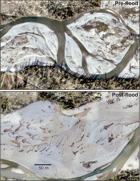
And the subsequent high-resolution before-and-after maps show a dramatic difference.
Running at an estimated 850 cubic metres per second upstream at Bragg Creek and reaching roughly 1,200 metres cubed per second (about a 500-year return or 0.2 per cent chance of occurring each year) at the Glenmore Dam in Calgary, the flooded Elbow River caused heavy bank erosion.
It widened the river in the study location by 100 metres in some spots, while chopping down the height of the river bank by five metres
And now, instead of meandering back and forth across the channel, the river runs much straighter than it did before the flood.
“It has completely wiped this out in terms of restructuring it,” said Hugenholtz.
The flood also washed most of the fine gravel downstream and redistributed larger rocks and boulders along the riverbed, making it more stable and less prone to change during future floods.
“The flood wiped out fine gravel and has decorated the area with massive boulders that require so much force to actually move that now there will be less mobility of the gravel through the system, which is important for changing the river in the future,” Hugenholtz said, adding it would take a much bigger flood than what occurred in 2013 to alter the river’s channel.
“We didn’t understand to this extent that a flood can really armour the river channel in this way and it requires a bigger flood to actually contribute to the same level of change in the future,” he said. “I don’t think we appreciated the level of reconfiguring and stabilizing the flood has done for the river and in most parts of the world we don’t get the opportunities to see this.”
As an educator, Hugenholtz said that is one of the elements of this study that excites him is the opportunity to use the data the team gathered between the two surveys and the subsequent high-definition images and maps as teaching tools.
“The thing in my profession and the work on change in the earth’s processes and systems we get excited when in the background today we don’t see any changes,” he said.
“It’s hard to connect people to the forces at work. This gives me the opportunity to say ‘look at that, that is a significant amount of change, we could not have forecasted that it would have done this sort of thing’. Now maybe that helps inform us moving into the future, for either preventative or predictive work on rivers and floods, but any time we get the chance to see a massive transformation on the landscape is very exciting and it helps us to connect to people that these things are at work, but we just don’t have them every day and they usually come as violent episodes.”
Along with understanding how a river can change following a flood, Hugenholtz said the drones and the cameras and other sensors they can carry do offer other site-specific flood-related uses.
Even though the drones are only useful for surveying small areas (larger areas of land still require imagery collected by satellites and planes), Hugenholtz said the use of drones are constrained only by the imagination and sight lines. For example, Hugenholtz said drones could be used as a tool in flood forecasting by monitoring river or creek beds to check for debris, such as a rockslide that could dam a creek.
“This would fit in somewhere with many layers helping with the planning and the response on the ground,” he said.
Drones could also be used during a flood to inspect areas not readily accessible by foot, but still within visible range.
Already, the Town of Canmore has employed Hugenholtz and his students to survey Cougar Creek and the Bow River.
Tamminga, meanwhile, is also surveying Kananaskis River and Evan Thomas Creek as part of his PhD project, which since the flood has morphed from using drones to map fish habitat to a broader study of flood-affected rivers and creeks.
As that centimeter-per pixel before data is not available, the comparisons for the Kananaskis River, Evan-Thomas Creek and the Bow River are not of the same quality as the before-and-after images of the Elbow River. Even so, comparing current data to data collected through other means, Hugenholtz said the Kananaskis and Bow rivers and Even-Thomas Creek appear to have not experienced the same level of change as their counterpart.
“The Elbow River is a flashy river,” Hugenholtz said, “it responds very quickly to high magnitude events . . . (and) it was the one subject to the most change.”
It’s likely, he noted, that not every stretch of the Elbow River saw the same magnitude of change as the section surveyed along Redwood Meadows.
“This is a snapshot. It doesn’t mean every one-kilometre section had the same magnitude, but I suspect if we were able to find other data sets to look at this we would find similar changes in other areas along Elbow.”
The team’s research sharing the change in the Elbow River – UAS-based remote sensing of fluvial change following an extreme flood event – was published in the international journal Earth Surface Processes and Landforms.


