
Standing on a strip of bare ground on an alpine ridge sparsely scattered with stunted trees and fields of late-season snow, the jagged peaks of Kananaskis Country’s eastern flank pierce the cloud-wisped sky like shark’s teeth in translucent water.
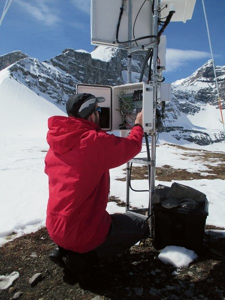
On a windless spring morning, Jonathan Conway approached a metal box secured to steel scaffolding erected on the exposed slope like a high-tech tripod to download data. The various instruments at this research station measure temperature, relative humidity, wind speed and direction, among numerous more intricate functions.
Among them, a sonic range finder gauges the height of the snow surface by sending out a “wee chirp” and measuring how long it takes for the sound to bounce back. A wind vein is equipped with a little propeller rather than the more common mini-cups, which too easily trap snow and ice and rime up.
“The propeller is the system used in the Arctic and Antarctic because it’s not as susceptible to rime,” Conway said. “It’s a much better choice up here.”
Indeed, this snow study site, one of seven at Fortress Mountain, sits at 2,330 metres elevation. Surveying the array of metal boxes, cylinders, probes and disks, I inquired about the tall thin rod protruding into the sky higher than any of the other instruments.
“Yep, that’s a lightning rod, it works like a decoy,” Conway replied. “You’re putting a tower on top of a ridge that does get electrical storms, so you’re asking for trouble. If it did get hit, the bottom would blow out and we’d lose $20,000 worth of instruments - plus hardware.”
A native New Zealander, where he earned his PhD in glaciology and climatology from the University of Otago, Conway arrived in Canmore early in the year to begin a two-year posting as a post-doctoral fellow at the University of Saskatchewan’s Centre for Hydrology, based out of the University of Calgary’s Kananaskis Field Station. Prior to visiting the Rockies, Conway conducted fieldwork in New Zealand’s Southern Alps and Antarctica’s McMurdo Ice Shelf.
Working in the Canadian Rockies where topography and climate are different from those regions enables Conway to compare and contrast them to New Zealand’s mountain environments, while also learning new field, scientific and computer modelling skills. Exchanging ideas and approaches to scientific studies benefits researchers from both countries.
Through his work, Conway will contribute to the Changing Cold Regions Network, a nation-wide project that looks at changes in water resources through Western and Northern Canada. In particular, he’s aiming to provide better science to the models used to understand and forecast changes in mountainous regions.
The standard snowmelt theories that hydrologists have relied on since the 1960s were developed in the Canadian prairies, because that’s where it was affordable and physically feasible to conduct research – in addition to being necessary to estimate snowmelt rates as a component of prairie flooding. As a result, the models researchers use have never been able to accurately factor in the characteristics unique to mountain terrain.
“Nowadays, instruments like this can stand up to the wind and snow,” Conway said. “We learn a lot about radiation and temperature and thermal energy. The Fortress site is ideal in this regard as it has such extreme topography and a range of surface cover. When you get into the mountains, you have all these terrain features that create all these eddies on the air that cause the theories to break down. We have to come out and measure when is the theory good, when is it not good.”
For every day in the field, Conway spends two weeks in front of a computer screen. As he downloads data from another research site in a more sheltered location about a half hour’s walk away, he explained how each of five state-of-the-art instruments at one station records 20 measurements every second, totalling more than 8.6 million data points per day.
And, in the case of science, quantity does equal quality of information gained, as the more information researchers gather, the more valuable data can be applied to practical purposes. In the Rockies’ front ranges, more accurate and detailed information about how much water will be released when the winter’s snowpack melts into the streams and rivers that flow through Calgary to Saskatchewan’s farms translates to improved planning ability for droughts and floods – like the one that submerged much of southern Alberta in 2013.
To that end, with seven sites arrayed in carefully selected locations around Fortress, Canadian researchers are benefiting from one of the most elaborate snow study sites in North America.
The Fortress Mountain Snow Lab was established in the past year as one of several areas developed thanks to $835,000 in funding from the federal government, the province of Saskatchewan and the U of S towards the Canadian Rockies Hydrological Observatory. With seven elaborate stations set at different aspects, at different elevations from valley bottom to 2,300 metres, and with exposure to varying wind force and speeds, the facility far exceeds anything in Canada.
“I am absolutely delighted with the site,” said John Pomeroy, director of the U of S Centre for Hydrology. “We’ve never had so many sites condensed in one alpine area. It’s a true mountain snow laboratory in that we can measure snow redistribution, accumulation and melt under very different conditions at a similar elevation in a place with superbly deep and long-lasting snow. We’re also working to improve climate and weather model operation in mountain environments and to better understand snow physics so that snow can be better measured and managed.”
Aided by advances in technology, scientists can test theories and models of snowpack development and snowmelt activity, delving into a level of detail never before possible. They’ve also been able to set up delicate and expensive equipment that isn’t easy to use in other alpine areas, and until now has been limited to valley bottom sites. Some of the technology is barely a decade old, with some instrument models as young as four.
In combination with funding and technology, an indispensable component is access. Established in 1967, Fortress operated as a lift-serviced ski hill into the early 2000s, a locals’ favourite with the funkiest day lodge and most skiable powder glades in Western Canada. After surviving a succession of owners and legal disruptions, Fortress’s current owner, Fortress Mountain Holdings Ltd., has operated KPOW cat skiing on the mountain’s legendary powder slopes since 2009.
With that, the 16-kilometre access road that branches off Highway 40 is ploughed through the winter, and owners have granted the scientists clearance to drive to the resort’s base. From there, alpine sites are accessible via snowmobile, or by a 90-minute ski tour. Fortress Holdings, Pomeroy added, has been extraordinarily accommodating.
“Access helps a lot,” Pomeroy said. “At Fortress we can Skidoo right up and this helps us tremendously. When the logistics are easier, you can get a lot of science done.”
In comparison, accessing another of Pomeroy’s sites on Fisera Ridge, also in Kananaskis Country, takes a solid three hours of walking and snowshoeing uphill over rough terrain - one way.
“That really shortens the amount of science that can be done there,” Pomeroy said. “You can only stay up a couple of hours then have to come right back down. And there are safety concerns too. Blowing snow – to be in a blizzard in the alpine, you need superb logistics to be able to do it safely.”
In the interest of safety, both Conway and I wore avalanche transceivers and carried shovels and probes in our backpacks, our ears periodically tuning in to the crashing of wet spring avalanches cascading over the steep cliff bands of the surrounding peaks, some not far above one of the stations.
“That one is in a precarious spot,” Conway said. “We set that one up in summer, and we don’t go there in winter.”
For the researchers, the same springtime conditions that cause the snowpack to collapse and render skiing difficult or downright unpleasant are the same conditions that can be especially productive, particularly for the study of how sparse upper elevation forests affect rain on snowmelt events – exactly the type of event that contributed to the extreme debris flood that obliterated streambeds throughout the eastern slope last spring, including Canmore’s Cougar Creek.
Visiting our third site of the day, Conway admitted not all his field days are as pleasant as this one, recalling one mid-winter visit in -32 C, and skiing down a glacier in New Zealand lugging a 14-kilogram battery in his pack.
While insisting he’d never give up his field days, Conway said future plans for the Fortress snow lab include having all the sites transmitting data to one central station on a lower elevation ridge, so only that site would have to be downloaded manually.
However, it’s not only the researchers who must brave the elements.
“Up at Fortress we’re always battling the cold and snow on sensitive instruments,” Conway said. “We’re pushing them to their limits really.”


