Water levels in the Bow River and its tributaries started running high last week when high temperatures caused rapid snowmelt, forcing closure of flooded trails in Banff and Lake Louise.
Water levels in the Bow River and its tributaries started running high last week when high temperatures caused rapid snowmelt, forcing closure of flooded trails in Banff and Lake Louise.
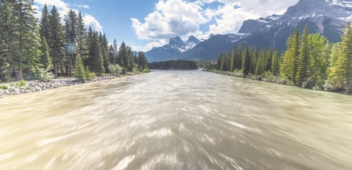
Although flows began dropping this week from the peak on Saturday (June 3), a high stream flow advisory remains in effect for the Bow River in Lake Louise, Banff and Canmore due to warm weather this week and predictions of significant rain to come.
Environment Canada predicts a low pressure system hitting the Washington coast Thursday evening is expected to bring significant rainfall this coming weekend over much of the western portions of Alberta.
John Pomeroy, a well known hydrologist, said the preliminary weather models he's looking at are suggesting up to 100 millimetres of rain starting Friday evening through Sunday in the Upper Kananaskis and Upper Bow River basins.
“There is a significant amount of rainfall forecast for this weekend in the mountain basins upstream of Canmore. That, with large volumes of melting snowpack, bears watching,” said Pomeroy, who leads the new Coldwater Laboratory in Canmore.
“In Canmore in May and June, we should always be ready for flooding and have personal safety plans in mind when storm systems approach.”
A high stream advisory went into effect Saturday after water levels in the Bow River near Banff rose about 0.9 metres and in the Pipestone River at Lake Louise by about 0.5 metres. They've dropped more than 25 cm since then.
Although water levels have dropped below their threshold, Parks Canada has left the spot closures in place due to the forecast warmer temperatures and precipitation.
The Bow River loop trail and a picnic area in Lake Louise remains closed because the trail flooded, while high water levels led to closure of the Fenland Trail near the Banff townsite.
The Bow River near Banff peaked at 270 cubic metres per second on Saturday. By comparison, it was running at 439 cubic metres per second in 2013 – the year of the devastating flood.
Pomeroy said the mountain parks had near record snowpack in many areas this year – and it lingered late but melted quickly with recent high temperatures.
“We had 200 mm of snowmelt over three days in some of the mountain areas,” said Pomeroy, the Canada research chair in water resources and climate change at the University of Saskatchewan. “When we had the flood in 2013, we had 250 mm of rain.”
In 2013, heavy rainfall occurred at all elevations from the U.S. border to Jasper National Park. A large area of the Rockies had at least 250 mm of rain, while some areas saw as much as 350 mm in three days.
This year however, Pomeroy said, the rapid snowmelt didn't cover as large an area, noting higher elevation snowmelt didn't cover as broad of an area, and there were low elevation areas where there wasn't enough snow to melt, or no snow at all.
“We were also fortunate it didn't rain heavily at the same time,” said Pomeroy. “That could have generated a rain-on-snowmelt flood.”
Many are now wondering whether the region will see heavy rainfall this month, which locals call ‘Monsoon June.'
Pomeroy said one of the many complex reasons for the heavy rain in 2013 was moisture coming off the prairies that moved into an upslope storm.
“What that means is for the flood of 2013 one of the conditions that was necessary for heavy rain was abnormally wet southern prairies,” he said.
“For this year, it's dry right now. We don't have the same conditions as we did in 2013. That doesn't guarantee anything, but it does make it less likely to have an event like that.”
Pomeroy leads the new Coldwater Laboratory in Canmore, where researchers are studying the effects of climate change on water, snow and glaciers and developing models to give earlier and more precise flood warnings.
“I think in three or four years we will have some models available to take out to the provinces,” said Pomeroy, who is the associate lead on the project.
“We simply have to do this. We've got to be able to give more warning.”