
The 2013 floods that inundated Canmore and Colorado shared many similarities, but the infrastructure in place to help predict such potentially devastating events is significantly different.
Such was the message shared by experts who participated in a presentation and panel discussion at Canmore Collegiate High School, Feb. 12. The event was hosted by the Changing Cold Regions Network, a collaborative research network comprised of 50 Canadian and international government and university researchers.
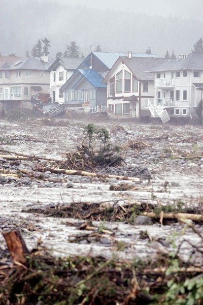
In a presentation that outlined the characteristics of storms that caused severe flooding in Alberta last June, and in the front range of the Colorado Rockies in September, Dr. Roy Rasmussen, a senior hydrometerologist at the National Center for Atmospheric Research in Boulder, Colo., described how both were upslope storms generated by warm moisture from the south - the Colorado storm likely influenced by two hurricanes over Mexico. As both rotated counter-clockwise and stalled over the front ranges, storms poured down a significant amount of water over a widespread area for an extended period of time.
Happening in June, the Alberta storm fell on upper mountain slopes that still held quite a bit of snow and the energy exchange brought on by the warm rain pummelling that snow contributed to increased runoff and destructive debris flow. The limited capacity of frozen soils to store water also contributed to flash flooding.
While the Alberta storm wasn’t quite as warm as Colorado’s, rain did fall at least as high as 2,315 metres at a Kananaskis research site maintained by the University of Saskatchewan’s Centre for Hydrology. Unlike the Colorado storm, Alberta’s storm generated a tremendous amount of lightning.
Despite the Alberta storm’s severity, U of S scientists led by Canmore resident Dr. John Pomeroy, have examined historical evidence and concluded it was not a once in a lifetime event, but a 32-year return event at Banff, and a 45-year return event at Calgary.
By comparison, U.S. scientists are describing the Colorado storm as a one in 500-year event.
The precipitation formed as rain right up to 35,000 feet, rather than beginning as snow and turning to rain as it fell to lower, warmer elevations. And it happened in the normally dry month of September.
“That took a lot of people by surprise,” Rasmussen said. “We went to bed and in the morning we heard about all the floods.”
As the storm broke records for rainfall and for creek flow, forecasters scrambled to adjust to real-time challenges, which included the fact that surface instruments necessary to record precipitation data were destroyed in the path of flooding creeks.
“We had to quickly adjust to the fact this was a more tropical event,” Rasmussen said, adding the storm generated some 1,300 landslides, washed out bridges and destroyed 262 homes.
“That was something we’d never had before either,” Rasmussen said. “Nobody knew how to plan for it.”
That Colorado storm, Rasmussen said, has since prompted significant investment in infrastructure on behalf of the National Weather Service’s quest to improve U.S. researchers’ ability to predict and forecast storms in the future, as they, as well as Canadian researchers, believe that with climate change, both these storms are likely harbingers of storms to come.
Following Rasmussen’s presentation, audience members posed questions to an expert panel. In response to one person’s inquiry as to why Canmorites never heard the word “flood” prior to Cougar Creek exploding its banks, the audience learned how unlike in the U.S., where the National Weather Service issues flood warnings, Environment Canada does not. Flood warnings fall under provincial jurisdiction and mountain creeks are not monitored.
“(Alberta Environment’s) flood models are directed for rivers, not for mountain creeks,” Pomeroy said. “That was their focus; the Bow, and not the smaller creeks.”
“Their (Alberta Environment) system is not capable of forecasting where they don’t have a stream gauge,” added Dr. Kevin Shook, a former Alberta Environment forecaster now with the U of S Centre for Hydrology. “We don’t have a system like they do in the U.S.”
While the Alberta Environment system is capable of taking into account such factors as existing snowpack, it is limited, Shook said.
“The model that provincial forecasters use does include snow, but in a very simple way,” Shook said. “It’s not as sophisticated as the one researchers use.”
When asked if Alberta had sufficient monitoring stations to make use of sophisticated U.S. forecasting models, Shook, Pomeroy and Dr. Ron Stewart of the University of Manitoba, replied in unison.
“No.”
“The investment in infrastructure is wholly lacking,” Shook said. “The number of people we have in Canada doing river forecasting is minute.”
“We can write all the models we want - and we do create these models in the Bow Valley,” Pomeroy said. “But universities should not run them operationally. Governments have to run these models and coordinate with the researchers to make sure that what they run is up to date and working well.”
Shook then described how, while working for Alberta Environment, he visited the River Forecast Centers in Portland, Ore. and Sacremento, where the level of technology, money and personnel was far beyond Canada’s.
“I felt like a poor hillbilly cousin going there,” Shook said. “It was like going from the Stone Age to Star Wars.”
For example, Alberta Environment maintains 10 sparsely distributed snow data monitoring stations, compared to some 113 in a region of similar size and area in Colorado’s Rockies.
And, Shook pointed out, “Alberta has the most resources of any province.”
“From our station count in 2008, to reach the standards set out by the World Meteorological Organisation for monitoring in mountain areas, snowfall and rainfall measuring station numbers above 1,500 metres in the Canadian Rockies would have to increase 22.5 times,” Pomeroy said. “We have a few more stations now, but not that many more.”
One of the biggest shortcomings of Canada’s operational infrastructure, Shook pointed out, is a substantial disconnect between researchers and those working operationally.
“We don’t have people whose job it is to take science and develop it into tools,” Shook said.
And while the U.S. is ramping up its ability to better predict extreme weather events, after a century of improvements which enabled Environment Canada’s network of climate stations to take reliable precipitation measurements, the system has been in steady decline for the past two decades.
“Since the mid-1990s the number of Environment Canada climate stations taking reliable precipitation measurements in the Prairie and Arctic part of Canada has dropped from about 180 to about 50 stations,” Pomeroy said. “This has brought the network density back to the level of about 1917. That’s the First World War. We’ve gone backwards in our ability to reliably measure precipitation.”


