
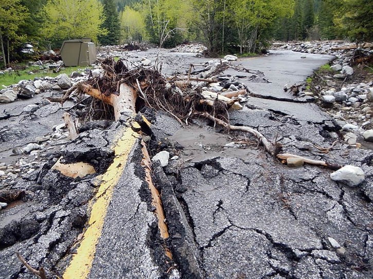
The first full summer of restoration work in Kananaskis Country after the June 2013 floods has seen multiple trails restored, bridges replaced and planning undertaken to determine what changes are needed to prevent the loss of recreation infrastructure during future events.
Provincial Parks staff were on hand last Thursday (Nov. 6) at Elevation Place to provide the public with details of what has been achieved so far and what work is still needed over the next two years of reconstruction.
Kananaskis infrastructure manager Stan Vanderhelm said replacing bridges that were washed out meant putting in larger structures.
“A lot of the trail bridges that are being placed, the spans in a lot of locations are different because you can see that a lot of the waterways are wider than they were previously, so some of the bridges will have to be replaced with larger bridges, but generally speaking we are trying to find the most cost effective solution that is going to last in future events,” Vanderhelm said.
Areas with new bridges include one on the paved bike trail over Boulton Creek, Rolly Road Trail and one along the trail over Buller Pass from Spray Lakes Road. Vanderhelm said bridge replacement is assessed on a case-by-case basis and in places where material is available for natural log bridge spans those will be constructed.
Many trails also saw changes and rerouting as a result of the flood including 120-metre reroute of Three Isle Trail in Peter Lougheed Provincial Park and the Maude/Lawson Trail and Upper Lake Trail at the Kananaskis River.
“Generally speaking the rebuilding we are doing is trying to put (trails) into places that don’t sustain damage in the future,” Vanderhelm said.
Bow Valley Trail Crew leader Jeff Eamon spent the summer focused on Ribbon Creek and along with Friend of Kananaskis volunteers rebuilt 3.5 kilometres of the trail from Link Bridge to the Ribbon Falls campground.
“It will take a bigger event than last year’s to take out some of the stuff we have put in; the bridges are higher, the trails are higher and in better shape,” Eamon said. “Next year there will be a lot more clean up.”
Summer 2015 work includes the lower Ribbon Creek Trail from the parking lot to Link Trail bridge. A 2.5 kilometre section of the trail was extensively damaged in the flood and the creek is now routed differently.
Galatea is also priority for next year, as rehabilitation requires new longer, higher, bridge construction and realignment of large sections of the trail.
Some of the campgrounds and day use areas that were completely inundated by floodwaters and destroyed, however, won’t be reconstructed.
Alberta Parks spokesperson Jill Sawyer said Pickle Jar day use area is one area that will be decommissioned.
“This is the only place I have seen where it looks like water came up from underneath the asphalt and basically destroyed everything,” she said.
Vanderhelm said areas that sustained extensive damage make it difficult to restore and unwise knowing that it is in the path of a mountain creek or river for flooding after the 2013 event.
“We have a number of sites like that that are just so extensively damaged you have no place to start,” he said. “Elbow Falls for example is similar in that the landscape has changed so much that we have nothing to reclaim.”
The flood washed away an estimated 17,000 square metres of land mass near Elbow Falls viewpoint and many of the tables, pathways and fire pits were washed away.
This summer preliminary work was done clearing debris and the parking lot and viewpoint were open to the public. Planning work is still underway for the picnic area, as many sites were lost in the flood. A portion will either be replaced on site, or additional capacity added to a nearby area. Allen Bill Pond was completely washed out by the Elbow River and what remains of the day-use area will be recovered.
Design work is underway as well for an access road to River Cove group campground, as a large section was eroded in the flood.
Major erosion and subsequent undermining of the access road to the Sandy McNabb day use area along the Sheep River has put that area in question. All picnic facilities were washed away and planning is underway to decide the future of the site. However, the ski trails were not affected and will be open this winter.
The Sheep Falls day-use area, meanwhile, will be completely restored, as there was only minor erosion.
Etherington Creek was armoured and bermed this summer and debris cleaned up and the access road repaired. However, the Sentinel day use area was washed out and planners are considering several alternatives for replacing those facilities.
Armouring of Evan Thomas Creek and the Kananaskis River south of the village was done and more planned for 2015-16. Engineered structures are planned to protect the water intake for Nakiska for snowmaking and the new wastewater treatment plant.


